
| China Geological Survey Chinese Academy of Geological Sciences | Host |
| 科学出版社 | Publish |
| Citation: |
GAO Mengmeng, LI Ruimin, XU Huizhen, ZENG Qingshi, WANG Yiping, JING Jihong, LI Xiaolei, YIN Ming, ZHANG Xiangyuan. 2019. Database of Geological Environmental Map System of China Based on MapGIS[J]. Geology in China, 46(S2): 130-140. doi: 10.12029/gc2019Z214

|
Database of Geological Environmental Map System of China Based on MapGIS
-
Abstract
The Database of Geological Environmental Map System of China is China’s first national database with uniform structure, format and codes, covering five professional fields, namely, geological environment, geologic hazards, groundwater, geological environment of mines and geological relics (geoheritage). Using 1∶1 000 000 data sources as the geographic information base, this database is built on 1∶500 000 environmental geological surveys in different provinces, county- and city-level geologic hazard surveys, 1∶50 000 geologic hazard surveys in key areas, the latest groundwater resources assessment, the second national survey of the geological environment of mines and investigation of such in areas with concentrated mining, and the first survey of geological relics. According to uniform requirements, it integrated the data of hydrological, engineering and environmental geological surveys and monitoring data over the past 20 years as well as the latest related research results. It has a unified system library (symbol, color, pattern and line libraries), with attributes established according to uniform coding rules and requirements, and with maps standardized according to uniform finishing and legend. The database contains 163 professional map layers with a total number of 337 833 elements and a capacity of 8.8 GB. It lays a solid foundation for the dynamic management and updating of maps and the construction of a digital geological environment, and provides detailed fundamental information for the protection and management of China’s geological environment, spatial planning of national territory, ecological restoration and the prevention and control of geologic disasters.
-
Keywords:
- geological environment /
- national database /
- MapGIS /
- map layer /
- attribute data
-

-
References
[1] 邓起东. 2007. 中国活动构造图[M]. 北京: 地震出版社. [2] 段永侯. 1992. 中国环境地质图系[M]. 北京: 中国地图出版社. [3] 韩坤英, 丁孝忠, 范本贤, 耿树方, 剧远景, 王振洋. 2005. 基于GIS的区域地质编图方法[J]. 中国地质, 32(4): 713−717. doi: 10.3969/j.issn.1000-3657.2005.04.022 [4] 郝爱兵, 李瑞敏, 石菊松, 等. 2019. 中国地质环境图系[M]. 北京: 地质出版社. [5] 柯学, 丁孝忠, 韩坤英, 剧远景, 庞健峰. 2008. 基于MAPGIS建立地质图数据库的方法——以全国1∶100万地质图数据库为例[J]. 地质力学学报, 14(2): 186−192. doi: 10.3969/j.issn.1006-6616.2008.02.010 [6] 李炳元. 1994. 中国地貌图[M]. 北京: 科学出版社. [7] 李瑞敏. 2015. 全国地质环境图系编图技术要求[Z]. 中国地质环境监测院. [8] 梁国玲, 张永波, 张礼中, 陈京生, 周小元, 张春英. 2008. GIS环境下的中国环境地质图系空间数据库建设[J]. 南水北调与水利科技, 6(6): 23−27. doi: 10.3969/j.issn.1672-1683.2008.06.007 [9] 庞健峰, 丁孝忠, 韩坤英, 曾勇, 陈安蜀, 张艳玲, 张庆合, 姚冬生. 2017. 1∶100万中华人民共和国数字地质图空间数据库[J]. 中国地质, 44(S1): 8−18. [10] 王欢, 邓书金, 刘江, 林志龙. 2017. 基于MapGIS的重庆市地质环境三级分区及编图[J]. 资源环境与工程, 31(5): 624−627. [11] 徐友宁, 何芳, 张江华, 乔冈, 等. 2011. 中国矿山环境地质图[M]. 西安: 西安地图出版社. [12] 叶天竺, 黄崇轲, 邓志奇. 2017. 1∶250万中华人民共和国数字地质图空间数据库[J]. 中国地质, 44(S1): 19−24. [13] 殷跃平. 2013. 中国地质环境图系[M]. 西安: 西安地图出版社. [14] 张发旺, 程彦培, 董华, 等. 2012. 亚洲地下水系列图[M]. 北京: 中国地图出版社. [15] 张宗祜, 秦毅苏, 等. 2004. 中国地下水资源图[M]. 北京: 中国地图出版社. [16] 张宗祜, 孙继超, 等. 2006. 中国地下水环境图[M]. 北京: 中国地图出版社. [17] 曾青石. 2015. 全国地质环境图系建库技术要求[Z]. 中国地质环境监测院. [1] Deng Qidong. 2007. Active structure map of China[M]. Beijing: Earthquake Press (in Chinese). [2] Duan Yonghou. 1992. Environmental geological map system of China[M]. Beijing: China Map Publishing House (in Chinese). [3] Hao Aibing, Li Ruimin, Shi Jusong, et al. 2019. Geological environmental map system of China[M]. Beijing: Geological Publishing House (in Chinese). [4] Han Kunying, Ding Xiaozhong, Fan Benxian, Geng Shufang, Ju Yuanjing, Wang Zhenyang. 2005. Methods of regional geological map production based on GIS[J]. Chinese Geology, 32(4): 713−717 (in Chinese with English abstract). [5] Ke Xue, Ding Xiaozhong, Han Kunying, Ju Yuanjing, Pang Jianfeng. 2008. Method For The Construction Of The Geological Map Database Based On MapGIS−Example From The 1∶1 000 000Geological Map Database Of China[J]. Journal of Geomechanics, 14(2): 186−192 (in Chinese with English abstract). [6] Li Bingyuan. 1994. Landform map of China[M]. Beijing: Science Press (in Chinese). [7] Li Ruinmin. 2015. Technical requirements for mapping of national geological environment map system[Z]. Beijing: China Institute for Geoenvironmental Monitoring (in Chinese). [8] Liang Guoling, Zhang Yongbo, Zhang Lizhong, Chen Jingsheng, Zhou Xiaoyuan, Zhang Chunying. 2008. Construction of the Spatial Database of Chinese Environmental Geological Map System by GIS[J]. South-to-North Water Transfers and Water Science & Technology, 6(6): 23−27 (in Chinese with English abstract). [9] Pang Jianfeng, Ding Xiaozhong, Han Kunying, Zeng Yong, Chen Anshu, Zhang Yanling, Zhang Qinghe, Yao Dong sheng. 2017. The national 1:1 000 000 geological map spatial database[J]. Geology in China, 44(S1): 10−23. [10] Wang Huan, Deng Shujin, Liu Jiang, Lin Zhilong. 2017. Geological Environment Three-level Partition and Mapping in Chongqing Based on MapGIS[J]. Resources Environment & Engineering, 31(5): 624−627 (in Chinese with English abstract). [11] Xu Youning, He Fang, Zhang Jianghua, Qiao Gang, et al. 2011. Environmental Geological Map of China's Mines M]. Xi’an: Xi'an Map Publishing House (in Chinese). [12] Ye Tianzhu, Huang Chongke, Deng Zhiqi. 2017. Spatial database of 1:2 500 000 digital geologic map of People’s Republic of China[J]. Geology in China, 44(S1): 24−31. [13] Yin Yueping. 2013. Geological environmental map system of China[M]. Xi’an: Xi'an Map Publishing House (in Chinese). [14] Zeng Qingshi. 2015. Technical requirements for the database construction of the national geological environment map system[Z]. Beijing: China Institute for Geoenvironmental Monitoring (in Chinese). [15] Zhang Fawang, Cheng Yanpei, Dong Hua, et al. 2012. Groundwater series of Asia[M]. Beijing: China Map Publishing House (in Chinese). [16] Zhang Zonghu, Qin Yisu, et al. 2004. Groundwater resources map of China[M]. Beijing: China Map Publishing House (in Chinese). [17] Zhang Zonghu, Sun Jichao, et al. 2006. Groundwater environmental map of China[M]. Beijing: China Map Publishing House (in Chinese). -
Access History
Figures(2)
Tables(8)

Export File
Citation
GAO Mengmeng, LI Ruimin, XU Huizhen, ZENG Qingshi, WANG Yiping, JING Jihong, LI Xiaolei, YIN Ming, ZHANG Xiangyuan. 2019. Database of Geological Environmental Map System of China Based on MapGIS[J]. Geology in China, 46(S2): 130-140. doi: 10.12029/gc2019Z214
Format
Content
 DownLoad:
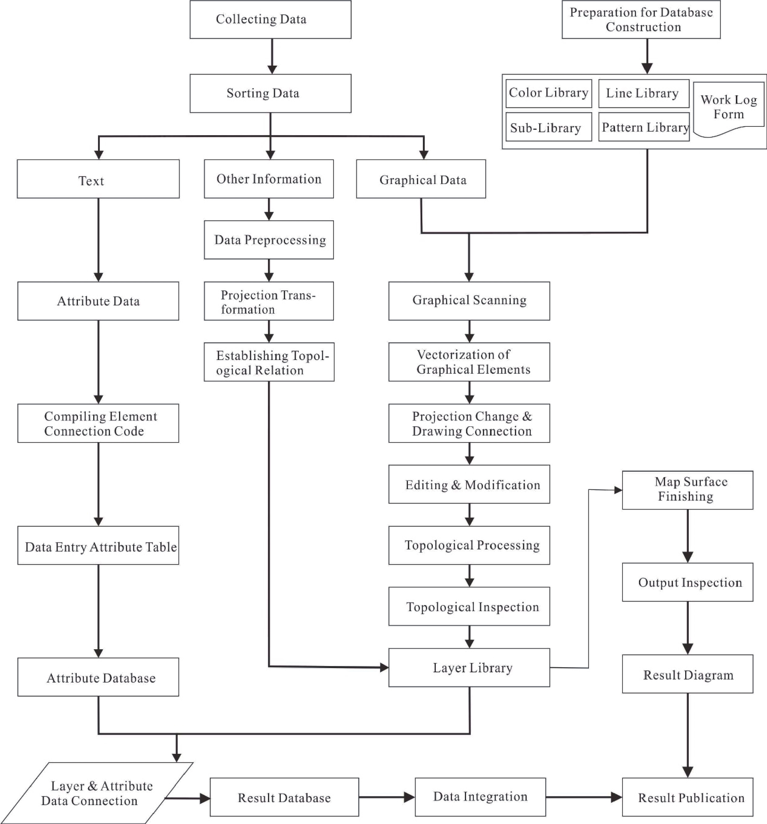
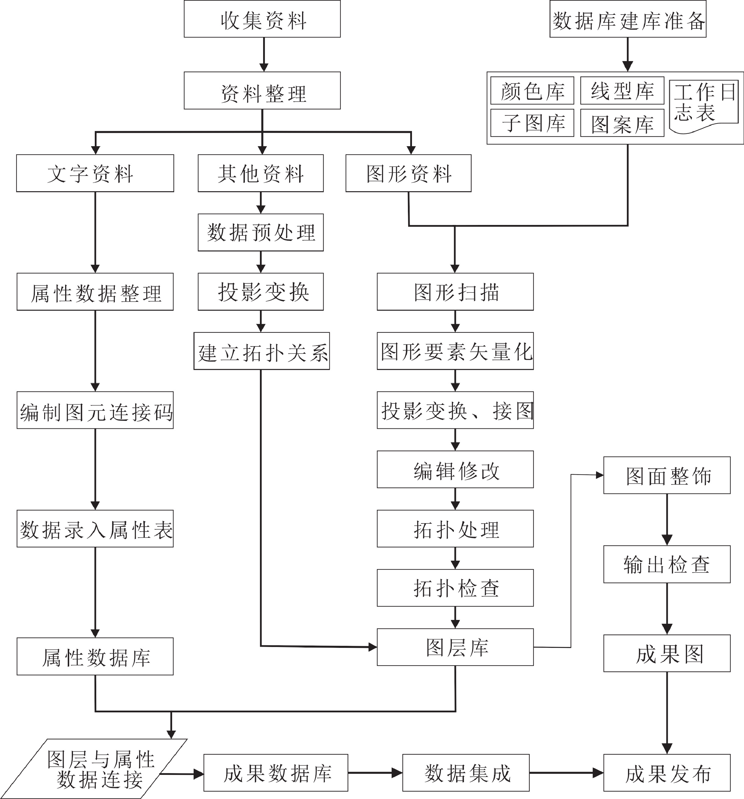
- Figure 1.
-
Figure 1.
Database Construction Workflow of the Map System