
| China Geological Survey Chinese Academy of Geological Sciences | Host |
| 科学出版社 | Publish |
| Citation: |
ZHANG Ao, SHAO Changsheng, WANG Cen, YANG Yanlin, LU Tao. 2019. Dataset of the Environmental Geological Survey on a Scale of 1∶50 000 in the Puqi County (Present Chibi City) Map Sheet, Hubei Province[J]. Geology in China, 46(S2): 50-59. doi: 10.12029/gc2019Z205

|
Dataset of the Environmental Geological Survey on a Scale of 1∶50 000 in the Puqi County (Present Chibi City) Map Sheet, Hubei Province
-
Abstract
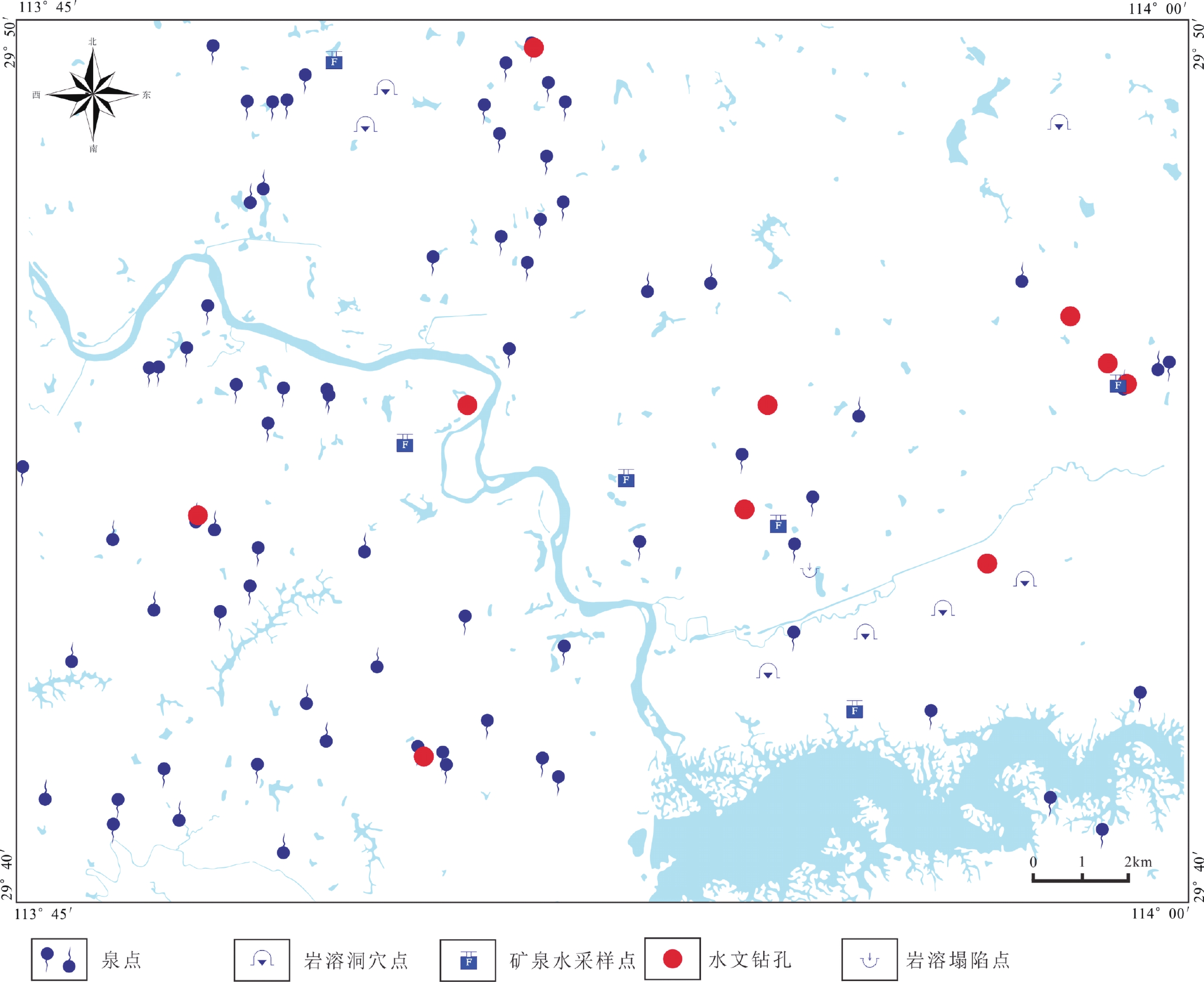
The environmental geological survey on a scale of 1∶50 000 in the Puqi Map Sheet (also referred to as the Survey) was carried out by relying on the project titled Environmental Geological Survey on a Scale of 1∶50 000 in the City Clusters of the Middle Reaches of the Yangtze River Along Xianning – Yueyang and Nanchang – Huaihua High-speed Railway initiated by the China Geological Survey. The dataset obtained through the Survey (also referred to as the Dataset) was developed by methods such as the hydrogeological survey, karst collapse survey, hydrogeological drilling and water-quality testing and analysis. It consists of the data of 73 spring survey points, test and analystical results of mineral water from 7 water samples and the data from 1 karst collapse point, 7 karst cave points and 10 hydrological boreholes. The detailed contents of these data are as follows: the results of the spring water survey include locations of spring survey points, water quality indices to be tested in the field and the genesis of spring water. The analytical results of mineral water are the ones reaching the requirements of mineral water according to the indoor testing of water samples taken from spring points and hydrological boreholes in the Puqi County Map Sheet. The data of karst collapses mainly include location of karst collapses, features of collapse pits, geological background and the state after collapse. The survey results of karst caves include the location, development features and development and utilization of the caves. The data of boreholes contain the location, diameter and depth of the boreholes. The Dataset will provide an important geological source for the planning and construction of towns, safe utilization of land and the development of high-quality geological resources in Chibi City.
-

-
References
[1] 付立新. 2012. 湖北省赤壁市城区生活饮用水水质监测分析[J]. 环境卫生学杂志, 10(2): 221−224. [2] 龚磊, 王新峰, 宋绵, 李红燕, 肖则佑, 胡啟锋, 王进, 吴琳伟, 王磊, 缪赛. 2019. 赣南兴国和宁都脱贫攻坚1∶50 000水文地质调查数据集[J]. 中国地质, 46(S1): 11−17. [3] 马洪云, 李成柱, 张俊. 2018. 鄂尔多斯盆地地下水无机指标数据集(2014−2015)[J]. 中国地质, 45(S1): 27−31. [4] 中华人民共和国国家质量监督检验检疫总局. 2008. 饮用天然矿泉水: GB 8537−2008 [S]. 北京: 中国标准出版社. [5] 中华人民共和国国土资源部. 2014. 水文水井地质钻探规程: DZT 0148−2014 [S]. 北京: 中国标准出版社. [6] 中华人民共和国国土资源部. 2015. 水文地质调查规范(1∶50 000): DZT 0282−2015 [S]. 北京: 地质出版社. [1] General Administration of Quality Supervision, Inspection and Quarantine of the People’s Republic of China. 2008. Drinking Natural Mineral Water: GB 8537−2008[S]. Beijing: Standards Press of China (in Chinese). [2] Ministry of Land and Resources of the People’s Republic of China. 2014. The specification for hydrogeological well drilling: DZ/T 0148−2014 [S]. Beijing: Standards Press of China (in Chinese). [3] Ministry of Land and Resources of the People’s Republic of China. 2015. Specification for hydrogeological survey(1∶50 000): DZ/T 0282−2015[S]. Beijing: Geological Publishing House (in Chinese). [4] Fu Lixin. 2012. Monitoring Analysis on the Quality of Drinking Water in Urban Areas of Chibi City[J]. Journal of Environmental Hygiene, 10(2): 221−224 (in Chinese with English abstract). [5] Gong Lei, Wang Xinfeng, Song Mian, Li Hongyan, Xiao Zeyou, Hu Qifeng, Wang Jin, Wu Linwei, Wang Lei, Miu Sai. 2019. 1∶50 000 Hydrogeological Survey Dataset for Poverty Alleviation in Xingguo and Ningdu Counties, South Jiangxi[J]. Geoloy in China, 46(S1): 15−23. [6] Ma Hongyun, Li Chengzhu, Zhang Jun. 2018. Inorganic indicator dataset for groundwater in Ordos Basin (2014—2015)[J]. Geology in China, 45(S1): 35−40. -
Access History
Figures(4)
Tables(12)

Export File
Citation
ZHANG Ao, SHAO Changsheng, WANG Cen, YANG Yanlin, LU Tao. 2019. Dataset of the Environmental Geological Survey on a Scale of 1∶50 000 in the Puqi County (Present Chibi City) Map Sheet, Hubei Province[J]. Geology in China, 46(S2): 50-59. doi: 10.12029/gc2019Z205
Format
Content
 DownLoad:


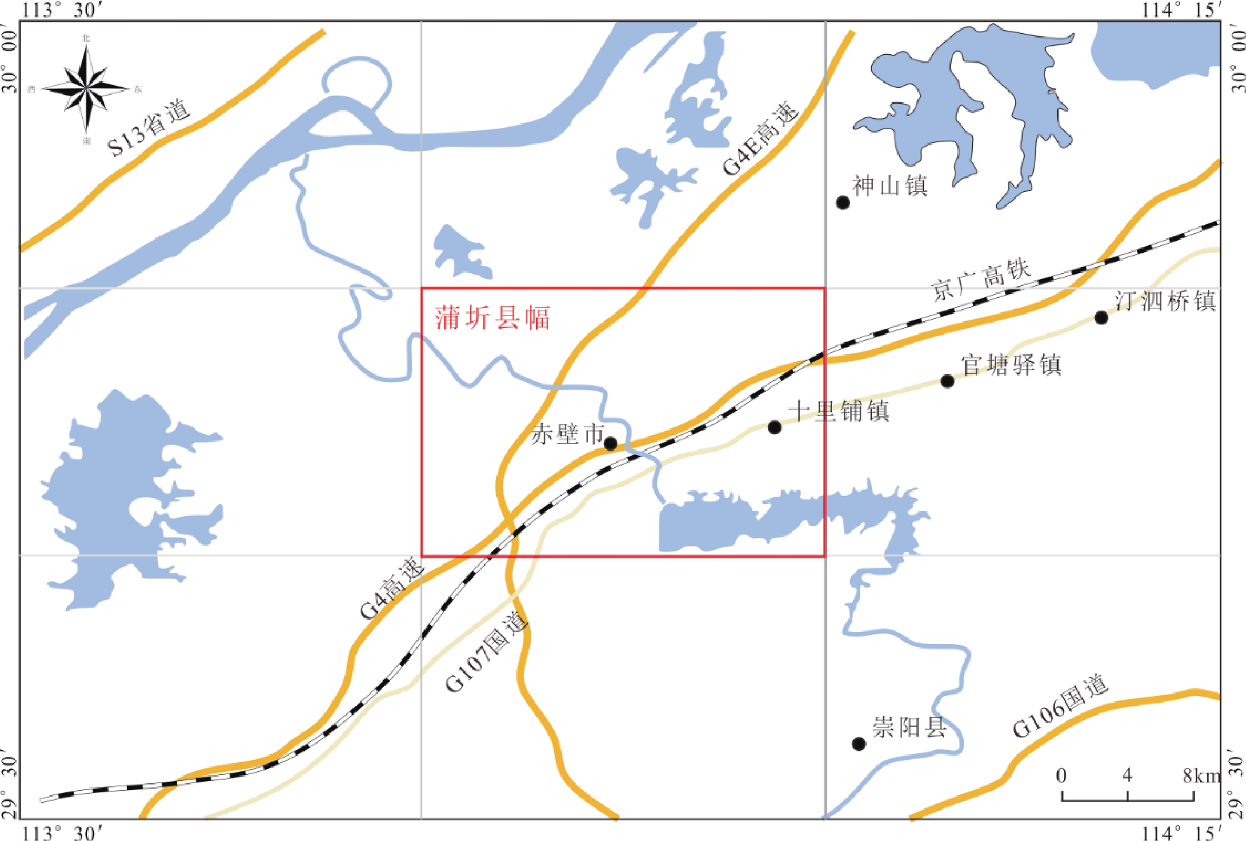
- Figure 1.
- Figure 2.
-
Figure 1.
Geographic Location Map of the Puqi County Map Sheet
-
Figure 2.
Distribution of the Groundwater survey points