
| China Geological Survey Chinese Academy of Geological Sciences | Host |
| 科学出版社 | Publish |
| Citation: |
LI Chenyang, WANG Xinchun, HE Chunzhen, WU Xuan, KONG Zhaoyu, LI Xiaolei. 2019. China National Digital Geological Map (Public Version at 1:200 000 Scale) Spatial Database[J]. Geology in China, 46(S1): 1-10. doi: 10.12029/gc2019Z101

|
China National Digital Geological Map (Public Version at 1:200 000 Scale) Spatial Database
-
Abstract
As the only one of its kind, China National Digital Geological Map (Public Version at 1:200000 scale) Spatial Database (CNDGM-PVSD) is based on China's former nationwide measured results of regional geological survey at 1:200 000 scale, and is also one of the nationwide basic geosciences spatial databases jointly accomplished by multiple organizations of China. Spatially, it embraces 1163 geological map-sheets (at scale 1:200 000) in both formats of MapGIS and ArcGIS, covering 72% of China's whole territory with a total data volume of 90 GB. Its main sources is from 1:200 000 regional geological survey reports, geological maps, and mineral resources maps with an original time span from mid-1950s to early 1990s. Approved by the State's related agencies, it meets all the related technical qualification requirements and standards issued by China Geological Survey in data integrity, logic consistency, location accuracy, attribution fineness, and collation precision, and is hence of excellent and reliable quality. The CNDGM-PVSD is an important component of China's national spatial database categories, serving as a spatial digital platform for the information construction of the State's national economy, and providing information backbones to the national and provincial economic planning, geohazard monitoring, geological survey, mineral resources exploration as well as macro decision-making.
-

-
References
[1] 李军. 2006. 数字地质图空间数据库建设与质量控制[D]. 长春: 吉林大学. http://cdmd.cnki.com.cn/Article/CDMD-10183-2006108871.htm [2] 刘锋英, 王新春, 李晨阳, 何春珍. 2002. 全国1∶20万数字地质图空间数据库建设技术平台[J]. 国土资源信息化, (6): 19−23. [3] 刘英才. 2013. 东北地区1∶20万区域地质图空间数据库元数据建设[J]. 地质与资源, 22(5): 415−418. doi: 10.3969/j.issn.1671-1947.2013.05.012 [4] 唐海燕. 2002. 《全国1∶20万数字地质图空间数据库》顺利通过成果评审并投入使用[J]. 江苏地质, (3): 153. [1] Li Jun. 2006. The Spatial Database Construction and Quality Monitoring of the Digital Geological Map [D]. Changchun: Jilin University (in Chinese). [2] Liu Fengying, Wang Xinchun, Li Chenyang, He Chunzhen. 2002. National 1∶200 000 Digital Geological Map Spatial Database Construction Technology Platform[J]. Land and Resources Informationzation, (6): 19−23 (in Chinese). [3] Liu Yingcai. 2013. Metadata Construction for the Spatial Database of 1∶200 000 Regional Geologic Map of Northeast China [J]. Geology and Resources, 22(5): 415−418 (in Chinese with English abstract). 10.3969/j.issn.1671-1947.2013.05.012 [4] Tang Haiyan. 2002. ‘National 1∶200 000 Digital Geological Map Spatial Database’ Passed the Assessment and Put into Practical Application[J]. Jiangsu Geology, (3): 153 (in Chinese). -
Access History
Figures(4)
Tables(4)

Export File
Citation
LI Chenyang, WANG Xinchun, HE Chunzhen, WU Xuan, KONG Zhaoyu, LI Xiaolei. 2019. China National Digital Geological Map (Public Version at 1:200 000 Scale) Spatial Database[J]. Geology in China, 46(S1): 1-10. doi: 10.12029/gc2019Z101
Format
Content
 DownLoad:
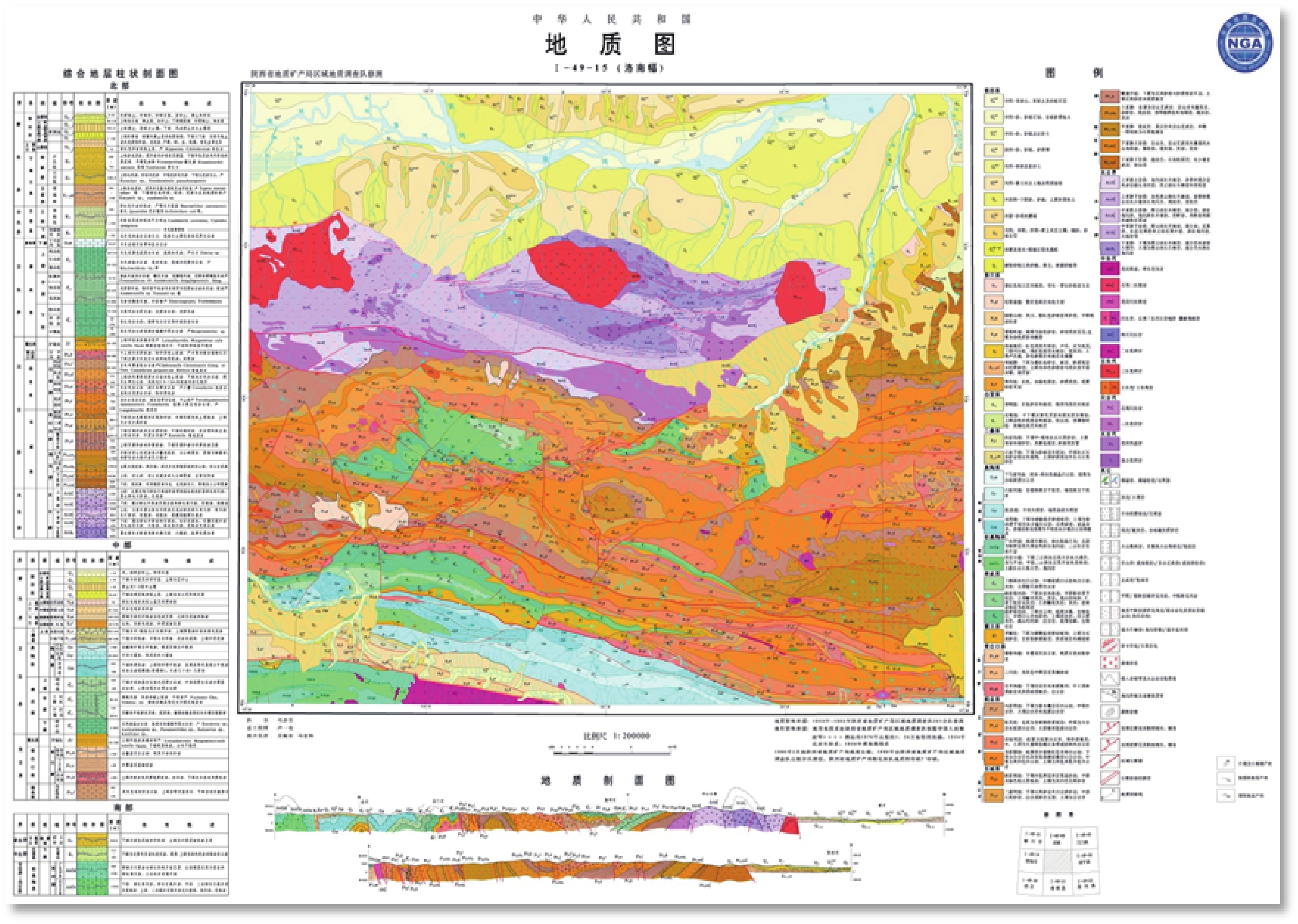


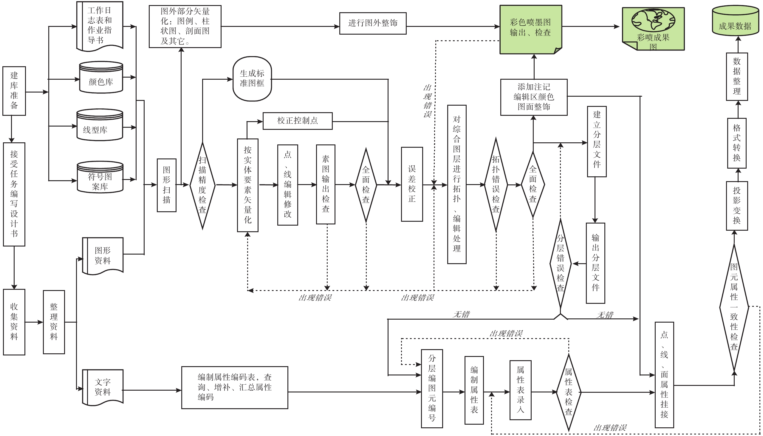
- Figure 1.
- Figure 2.
- Figure 1.
- Figure 2.