
| China Geological Survey Chinese Academy of Geological Sciences | Host |
| 科学出版社 | Publish |
| Citation: |
HAN Lele, DING Weicui, CHEN Xuanhua, LIU Meiling, WANG Ye, XU Shenglin, ZHANG Da, CUI Yanjun. 2019. Linear structure extraction and quantitative analysis of multi-source remote sensing information in West Junggar Basin[J]. Geology in China, 46(5): 1209-1223. doi: 10.12029/gc20190521

|
Linear structure extraction and quantitative analysis of multi-source remote sensing information in West Junggar Basin
-
Abstract
The western Junggar region, which is sandwiched between the nearly EW-trending Irtys fault and the Tianshan strikeslip fault system, has experienced long and complicated history of intracontinental tectonic deformation since the Late Paleozoic. The length, direction and spatial distribution of tectonic lineaments can not only reflect the strength and style of structural deformation but also indicate the mode of stress action. In this paper, the western Junggar region in northwest Xinjiang was selected as the research area. The spatial distribution and spectral information of fault structures in multi-source data such as ASTER and Landsat were displayed by color composite, principal component analysis(PCA), band ratio and Sobel filtering. The linear structures in the study area were extracted by combining Canny edge detection and visual interpretation. The principle and method of geostatistics were used to quantitatively analyze the extracted linear structures. The results show that the strike of the main faults determined by the optimum orientation of length in the study area is N50°-60°E, which represents the orientation of the distribution of the regional first-order structure, namely the Dalabut fault. The strike of the secondary faults determined by the optimum orientation of the number of linear structures is 80°-90° (in nearly EW direction), which represents the orientation of the regional third-order structures. The linear structures between the above two structures, namely moderate structures in number and length, represent the orientation of the regional secondary structure. The regional distribution of linear structures reveals the structural system composition and deformation characteristics of the western Junggar region under the action of the principal compressive stress in the NS direction. Therefore, the quantitative analysis of linear structures extracted from multi-source remote sensing image is of great significance for the determination of regional fault tectonic system.
-

-
References
Binam Mandeng E P, Bondjè Bidjeck L M, Takodjou Wambo J D, Taku A Jr; Bineli Betsi T, Solange Ipan A, Tchami Nfada L, Bitom Dieudonné L. 2018. Lithologic and structural mapping of the Abiete-Toko gold district in southern Cameroon, using Landsat 7 ETM+/SRTM[J]. Comptes Rendus Geoscience, 350(3):130-140. Carr J R. 1998. Visual basic program for principal components transformation of digital images[J]. Computers & Geosciences, 24(3):209-218. Cheng Lyu, Cheng Qiuming, Zuo Renguang, Wang Xueping. 2017. Mapping spatial distribution characteristics of lineaments extracted from remote sensing image using fractal and multifractal models[J]. Journal of Earth Science, 28(3):507-515. Chen Jianqiang, Wu hong.2005. Extraction and quantitative analysis of remote sensing geotectonic information in Dachang area[C]//Fifth China Academic Conference on Mine Geology and High-level Forum on Revitalizing Production Mine Resources in Northeast China(in Chinese with English abstract). Chen Xiaoyu, Liu Zhiping, Zheng Weimin. 2014. Fusion of ETM + image optimal bands composite and its quality evaluation[J]. Journal of Xinyang Normal University(Natural Science Edition), 2:218-222(in Chinese with English abstract). Chen Xuanhua, Chen Zhengle, Han Shuqin, Wang Zhihong, Yang Qi, Ye Baoying. 2012. Geothermochronology Of Mo-W Deposits in Balkhash Metallogenic Belt, Kazakhstan, Central Asia[J]. Journal of Earth Science, 37(5):878-892(in Chinese with English abstract). Chen Xuanhua, Chen Zhengle, Han Shuqin. 2017. TectonicMagmatic-Metallogenesis Evolution in Barkash-Western Junggar and its Adjacent Areas[M]. Beijing:Geological Publishing House(in Chinese with English abstract). Chen Xuanhua, Chen Zhengle, Yang Nong. 2009. Study on regional mineralizations and ore-field structures:Building of mineralizing tectonic systems[J]. Journal of Geomechanics, 15(1):1-19 (in Chinese with English abstract). Chen Xuanhua, Nie Lanshi, Ding Weicui, Wang Xueqiu, Wang Zhihong, Ye Baoying. 2015.The relationship between strike-slip tectonic system and geochemical anomalies in the West Junggar, northwestern China and its implication for mineral exploration[J]. Acta Petrologica Sinica, 31(2):371-387(in Chinese with English abstract). Chen Xuanhua, Wang Zhihong, Ye Nong, Chen Zhengle, Han Shuqin. 2010. Geological characteristics of and metallogenic model for large-scale sayak copper ore field in Balkhash metallogenic belt, Centralasia[J]. Journal of Geomechanics, 16(2):189-202(in Chinese with English abstract). Chen Xuanhua, Yang Nong, Ye Baoying, Wang Zhihong, Chen Zhengle. 2010. Tectonic system and its control on metallogenesis in Western Junggar as part of the central Asia multi-core metallogenic system[J]. Geotectonica et Metallogenia, 35(3):325-338(in Chinese with English abstract). Ding Weicui, Li Tingdong, Chen Xuanhua, Chen Jianping, Xu Shenglin, Zhang Yiping, Li Bing, Yang Qiang. 2019. IntraContinental deformation and tectonic evolution of the West Junggar Orogenic Belt, Central Asia:Evidence from remote sensing and structural geological analyses[J]. Geoscience Frontiers, DOI:10.1016/j.gsf.2019.08.001. Fan Chun, Su Zhe, Zhou Li. 2014. Kinematic features of Darlbute fault in northwestern margin of Junggar Basin[J]. Chinese Journal of Geology (Scientia Geologica Sinica), 49(4):1045-1058(in Chinese with English abstract). He HongLin. 2011. Some problems of aerial photo interpretation in active fault mapping[J]. Seismology & Geology, 33(4):938-950(in Chinese with English abstract). J Ramón Arrowsmith, Zielke O. 2009. Tectonic geomorphology of the San Andreas fault zone from high resolution topography:An example from the Cholame segment[J]. Geomorphology, 113(1/2):0-81. Jakob S, Bühler B, Gloaguen R, Breitkreuz C, Eliwa H A, El Gameel K. 2015. Remote sensing based improvement of the geological map of the Neoproterozoic Ras Gharib segment in the Eastern Desert (NE-Egypt) using texture features[J]. Journal of African Earth Sciences, 111:138-147. Jiang Wenliang, Zhang Jingfa, Shen Xuhui, Jiao Qisong, Tian Tian, Wang Xin. 2018. Application of high resolution remote sensing technology in the study of active faults[J]. Journal of Remote Sensing, 22(S1):192-211(in Chinese with English abstract). Klinger Y, Etchebes M, Tapponnier P. 2011. Characteristic slip for five great earthquakes along the Fuyun fault in China[J]. Nat. Geosci., 4(6):389-392. Kong Fanchen, Ding Guoyu. 1991. The implications of the fractal dimension values of lineaments[J]. Earthquake, 5:33-37(in Chinese with English abstract). Li Chenwei, Zhang Ruisi, Zhang Zhutong, Ceng Min. 2018. Tectonic interpretation and analysis based on multi-source remote sensing sata:A case study of Jitai River in Chayi, Tibet[J]. Remote Sensing Technology and Application, 33(4):657-665(in Chinese with English abstract). Li haitao, Tian Qingjiu. 2004. Introduction of ASTER data products'characteristics and plans[J]. Remote Sensing Information, 3:53-55, 47(in Chinese with English abstract). Li Xue, Li Xiaoli, Wang Qiuliang, Li Jinggang, Zhang Lifen, Liao Wulin. 2017. Research on faults extraction method based on multisource remote sensing data:A case of central water source area of the middle route of south-to-north water diversion project[J]. Journal of Geodesy and Geodynamics, 37(2):132-136(in Chinese with English abstract). Li Zongren, Zhang Kun, Li Xiaomin, Li Delin, Ma Shibin. 2016. Analysis of linear structural characteristics of remote sensing and prediction of ore finding[J]. Remote Sensing Information, 31(3):115-121(in Chinese with English abstract). Lin Wei, Sun Ping, Xue Zhenhua, Zhang Zhongpei. 2017. Structural analysis of Late Paleozoic deformation of central Dalabutefault zone, West Junggar, China[J]. Acta Petrologica Sinica, 33(10):2987-3001(in Chinese with English abstract). Liu Jiang, Zhang Jinjiang, Guo Lei, Qi Guowei. 2011. Kinematic Vorticity of the Daqingshan Detachment Fault and its Structural Implications[J]. Geotectonica et Metallogenia, 35(1):1-11(in Chinese with English abstract). Liu Xinxing, Chen Jianping, Zeng Min, Dai Jingjing, Pei Yingru, Ren Mengyi, Wang Na. 2015. Geological structural interpretation of Qiangduo area in Tibet based on multi-source remote sensing data[J]. Remote Sensing for Land & Resources, 27(3):154-160(in Chinese with English abstract). Luo Guowen, Yin Zhihong, Yang Shuwen, 2015. Present condition and prospect of ertracton and identification methods by using remote sensing technology in faults[J]. Land and Resources in Shangdong Province, 28(2):29-33(in Chinese with English abstract). Masoud A A, Koike K. 2011. Auto-detection and integration of tectonically significant lineaments from SRTM DEM and remotely-sensed geophysical data[J]. Isprs Journal of Photogrammetry & Remote Sensing, 66(6):818-832. Mu YuanRui, Kong Jie, Zhu YuFang, Zhang Jianshou. 2017. Lithology extraction from ASTER images in the east of setura town, Pishan county, west KunLun, Xinjiang[J]. West-China Exploration Engineering, 29(6):143-145, 148(in Chinese with English abstract). Qi Xin, Shao Changsheng, Chen Zhoufeng, Li Xue. 2012. Application of multi-source remote sensing data in fault structure interpretation[J]. Journal of Geodesy and Geodynamics, 32(4):90-93(in Chinese with English abstract). Sharifi A, Malian A, Soltani A. 2018. Efficiency evaluating of automatic lineament extraction by means of remote sensing (Case Study:Venarch, Iran)[J]. Journal of the Indian Society of Remote Sensing, 13:1-12. Shi Jianjie, Chen Xuanhua, Ding Weicui, Li Bing. 2017. Late Paleozoic ocean-continent transition in West Junggar, central Asian orogenic belt:Evidence from Late Carboniferous rhyolites[J]. Journal of Geomechanics, 23(1):150-160(in Chinese with English abstract). Su Yuanyuan, Zhang Jingfa, He Zhongtai, Jiang Wenliang, Jiang Hongbo, Li Qiang. 2015. Assessment of applying ZY-3 DEM data to quantitative study of active structures[J]. Remote Sensing for Land & Resources, 27(4):122-130(in Chinese with English abstract). Sui Zhilong, Li Dewei, Huang Chunxia, 2002. Remote sensing methods for research of fault structures[J]. Geography and Territorial Research, 18(3):34-37(in Chinese with English abstract). Wang Dehua, Zhang Jingfa, Yang Jiajia, Jiang Wenliang, Jiao Qisong. 2018. Application of remote sensing data in active fault surveying of Damxung area[J]. Journal of Geodesy and Geodynamics, 38(5):51-56, 79(in Chinese with English abstract). Wang Yangming, Zhang Jingfa, Liu Zhirong, Shen Xuhui. 2018.Active faults interpretation of Shannan area in Tibet based on multi-source remote sensing data[J]. Remote Sensing for Land & Resources, 30(3):230-237(in Chinese with English abstract). Wei Yongming, Lin Qizhong, Xiao Sang, Chen Yu, Wang Qinjun, Liu Qingjie, Wei Xianhu. 2015. Remote sensing identification of geological structures at different scales in western Junggar, Xinjiang and its prospecting significance[J] Geotectonica et Metallogenia, 39(1):76-92(in Chinese with English abstract). Xu Junlong, Wen Xingping, Yu Min, Li Chao, Wang Jun, Zhang Lijuan, Zhou Yang, Qiao Xu. 2014. An analysis of linear structures in the huize lead-zinc mine based on remote sensing images using the principle of geostatistics[J]. Geology and Exploration, 50(4):763-771(in Chinese with English abstract). Xu Junlong. 2014. Statistical Characteristics Analysis of Remote Sensing Linear Structures and Extraction of Alteration Information in Huize Lead-Zinc Mine, Yunnan Province[D]. Kunming University of Science and Technology (in Chinese with English abstract). Xu Shenglin, Chen Xuanhua, Li Tingdong, Shi Jianjie, Ding Weicui, Li Bing, Huang Penghui, Zhang Yiping, Zhang Yaoyao, Ma Feizhou. 2019.The Late Carboniferous-Early Permian OceanContinent Transition in the West Junggar, Central Asian Orogenic Belt:Constraints from Columnar Jointed Rhyolite[J]. Acta Geologica Sinica(English Edition), 93(2):265-282. Yan Rui, Zhang Jingfa, Jiang Wenliang, Jiao Mengmei. 2008. The interpretation of faults in Hangjinqi area of Ordos Basin using Multi-Source Rs Images[J]. Remote Sensing for Land & Resources, 2:88-91, 122(in Chinese with English abstract). Yao Shenghai, Huang Wei, Jiang Wenliang, Wang Xin. 2014. Late Quaternary activity characteristics of faults (Xitieshan section) in the northern margin of Qaidam basin[J]. Journal of Seismological Research, 37(S1):50-54(in Chinese with English abstract). Yu Min, Wen Xingping, Xu Junlong, Chao Jiangqin, Yang Yang, Wang Jun, Yi Bangjin. 2014. Application of extraction of remote sensing alteration anomalies based on fractal theory in Maoping lead-zinc deposit[J]. Remote Sensing Technology and Application, 29(5):853-860(in Chinese with English abstract). Yu Yong, Yuan Aiping. 2005. Quantitative analysis with high resolution remote sensing lineament in Gaolong gold deposit[J]. Guangxi Sciences, 12(3):200-202 (in Chinese with English abstract). Yuan Xiaoxiang. 2011. Multi-source Remote Sensing Data Application in Information Extraction of Active Tectonics[D]. Institute of Earthquake Forecasting, CEA(in Chinese with English abstract). Zhang Jingfa, Jiang Wenliang, Tian Tian, Wang Xin. 2016. High resolution remote sensing application research in active fault surveying[J]. Acta Seismologica Sinica, 38(3):386-398(in Chinese with English abstract). Zhang Wei, Yao Qi, Chen Hanlin, Yang Jinzhong. 2013. Remote sensing interpretation and extraction of structural information about active faults at Hangzhou, China, and their surroundings[J]. Journal of Earth Science, 24(6):1056-1067. Zheng Yadong, Wang Tao, Zhang Jinjiang. 2008. Theory and practice of kinematic vorticity[J].Geoscience Frontiers, 3:209-220(in Chinese with English abstract). Zumsprekel H, Prinz T. 2000. Computer-enhanced multispectral remote sensing data:A useful tool for the geological mapping of Archean terrains in (semi)arid environments[J]. Computers & Geosciences, 26(1):87-100. 陈建强, 吴虹. 2005.大厂地区遥感地质构造信息提取及定量分析[C]//中国矿山地质学术会议暨振兴东北生产矿山资源高层论坛. http://cpfd.cnki.com.cn/Article/CPFDTOTAL-ZGYN200508001024.htm 陈小瑜, 刘志平, 郑伟民, 陈文成. 2014. ETM+遥感影像最佳波段融合质量评价[J].信阳师范学院学报(自然科学版)2:218-222. 陈宣华, 陈正乐, 韩淑琴. 2017.巴尔喀什-西准噶尔及邻区构造-岩浆-成矿作用演化[M].北京:地质出版社. 陈宣华, 陈正乐, 韩淑琴, 王志宏, 杨屹, 叶宝莹. 2012.中亚巴尔喀什成矿带钼-钨矿床的地质热年代学[J].地球科学——中国地质大学学报, 37(5):878-892. 陈宣华, 陈正乐, 杨农. 2009.区域成矿与矿田构造研究——构建成矿构造体系[J].地质力学学报, 15(1):1-19. 陈宣华, 聂兰仕, 丁伟翠, 王学求, 王志宏, 叶宝莹. 2015.西准噶尔走滑断裂系元素分布特征及其成矿意义[J].岩石学报, 31(2):371-387. 陈宣华, 王志宏, 杨农, 陈正乐, 韩淑琴. 2010.中亚巴尔喀什成矿带萨亚克大型铜矿田矿床地质特征与成矿模式[J].地质力学学报, 16(2):189-202. 陈宣华, 杨农, 叶宝莹, 王志宏, 陈正乐. 2010.中亚成矿域多核成矿系统西准噶尔成矿带构造体系特征及其对成矿作用的控制[J].大地构造与成矿学, 35(3):325-338. 何宏林. 2011.活动断层填图中的航片解译问题[J].地震地质, 33(4):938-950. 姜文亮, 张景发, 申旭辉, 焦其松, 田甜, 王鑫. 2018.高分辨率遥感技术在活动断层研究中的应用[J].遥感学报, 22(S1):192-211. 孔凡臣, 丁国瑜, 1991.线性构造分数维值的含义[J].地震, 5:33-37. 李晨伟, 张瑞丝, 张竹桐, 曾敏. 2018.基于多源遥感数据的构造解译与分析——以西藏察隅吉太曲流域为例[J].遥感技术与应用, 33(4):657-665. 李海涛, 田庆久. 2004. ASTER数据产品的特性及其计划介绍[J].遥感信息, 3:53-55, 47. 李雪, 刘小利, 王秋良, 李井冈, 张丽芬, 廖武林. 2017.基于多源遥感数据的断裂构造提取方法研究——以南水北调中线工程核心水源区为例[J].大地测量与地球动力学, 37(2):132-136. 李宗仁, 张焜, 李晓民, 李得林, 马世斌. 2016.遥感线性构造特征分析与找矿预测[J].遥感信息, 31(3):115-121. 林伟, 孙萍, 薛振华, 张仲培.2017.西准噶尔达拉布特断裂带中段晚古生代构造分析[J].岩石学报, 33(10):2987-3001. 刘江, 张进江, 郭磊, 戚国伟. 2011.大青山伸展拆离断层运动学涡度研究及构造指示意义[J].大地构造与成矿学, 35(1):1-11. 吴传庆, 殷守敬, 朱利, 马万栋, 吴迪. 2015.基于多源遥感数据的西藏羌多地区地质构造解译[J].国土资源遥感, 27(3):154-160. 罗国文, 阴志宏, 杨树文.2012.断裂构造遥感识别和提取方法的现状与展望[J].山东国土资源, 28(2):29-33. 穆媛芮, 孔婕, 朱玉芳, 张建收. 2017.新疆西昆仑皮山县赛图拉镇东ASTER影像岩性提取研究[J].西部探矿工程, 29(6):143-145+148. 齐信, 邵长生, 陈州丰, 李雪. 2012.多源遥感数据在断裂构造解译中的应用[J].大地测量与地球动力学, 32(4):90-93. 史建杰, 陈宣华, 丁伟翠, 李冰. 2017.中亚造山带西准噶尔晚古生代洋陆转换与构造演化——来自晚石炭世流纹岩的证据[J].地质力学学报, 23(1):150-160. 隋志龙, 李德威, 黄春霞, .2002.断裂构造的遥感研究方法综述[J].地理与地理信息科学, 18(3):34-37. 王德华, 张景发, 杨佳佳, 姜文亮, 焦其松. 2018.遥感技术在西藏当雄地区活动断裂调查中的应用[J].大地测量与地球动力学, 38(5):51-56, 79. 王阳明, 张景发, 刘智荣, 申旭辉. 2018.基于多源遥感数据西藏山南地区活动断层解译[J].国土资源遥感, 30(3):230-237. 魏永明, 蔺启忠, 肖磉, 陈玉, 王钦军, 刘庆杰, 2015.新疆西准噶尔地区不同尺度地质构造的遥感标识特征及找矿意义[J].大地构造与成矿学, 39(1):76-92 宿渊源, 张景发, 何仲太, 姜文亮, 蒋洪波, 李强. 2015.资源卫星三号DEM数据在活动构造定量研究中的应用评价[J].国土资源遥感, 27(4):122-130. 徐俊龙, 温兴平, 余敏, 李超, 王军, 张丽娟, 2014.基于地质统计学原理的会泽铅锌矿遥感线性构造解析[J].地质与勘探, 50(4):763-771. 徐俊龙, 2014.云南会泽铅锌矿遥感线性构造统计特征分析及蚀变信息提取研究[D].昆明理工大学. http://cdmd.cnki.com.cn/Article/CDMD-10674-1014356287.htm 王飞跃, 吴军虎, 王俊峰, 赵小峰. 2008.多源遥感数据综合解译鄂尔多斯盆地杭锦旗地区地质构造[J].国土资源遥感, 2:88-91, 122. 姚生海, 黄伟, 姜文亮, 王鑫. 2014.柴达木盆地北缘断裂(锡铁山段)晚第四纪活动性特征[J].地震研究, 37(S1):50-54. 余敏, 温兴平, 徐俊龙, 晁江琴, 杨炀, 王军.2014.基于分形的遥感蚀变异常提取在毛坪铅锌矿中的应用[J].遥感技术与应用, 29(5):853-860. 余勇, 袁爱平.2014.高龙金矿区高分辨率遥感线性构造定量分析[J].广西科学, 12(3):200-202. 袁小祥, 2011.多源遥感数据在活动构造信息提取中的应用研究[D].中国地震局地震预测研究所. http://cdmd.cnki.com.cn/Article/CDMD-85405-1011159292.htm 张景发, 姜文亮, 田甜, 王鑫. 2016.活动断裂调查中的高分辨率遥感技术应用方法研究[J].地震学报, 38(3):386-398. 郑亚东, 王涛, 张进江.2008.运动学涡度的理论与实践[J].地学前缘, 3:209-220. -
Access History

Figures(13)

Export File
Citation
HAN Lele, DING Weicui, CHEN Xuanhua, LIU Meiling, WANG Ye, XU Shenglin, ZHANG Da, CUI Yanjun. 2019. Linear structure extraction and quantitative analysis of multi-source remote sensing information in West Junggar Basin[J]. Geology in China, 46(5): 1209-1223. doi: 10.12029/gc20190521
Format
Content
 DownLoad:


-
Figure 1.
Structural geological map of West Junggar region (modified from Chen et al., 2011)
-
Figure 2.
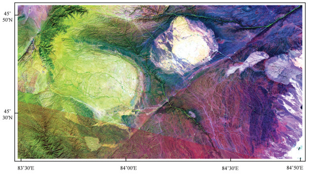
False color composition image of ASTER B6(R) B3(G) B1(B) in the West Junggar
-
Figure 3.
False color composition image of ETM+ B7(R) B4(G) B1(B) in the Western Junggar
-
Figure 4.
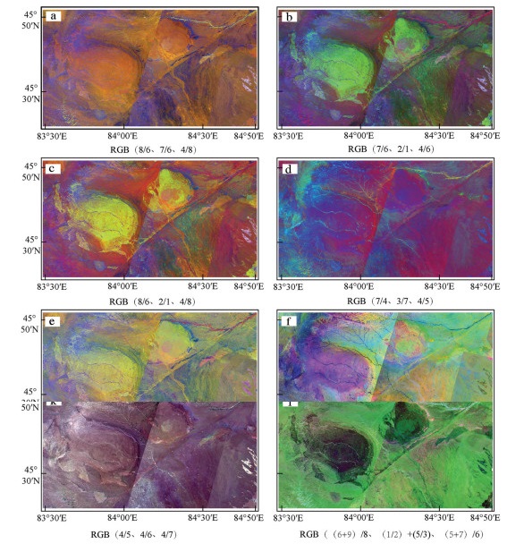
RGB comparison image of band ratios from ASTER in the Western Junggar
-
Figure 5.
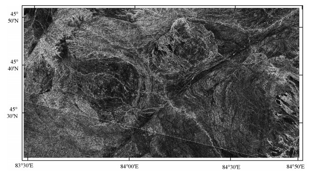
Sobel filtered Image in Western Junggar
-
Figure 6.
Canny edge detection result in Western Junggar (parameter 0.55)
-
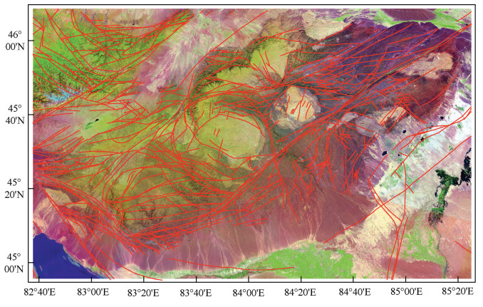
Figure 7.
Interpretation map of linear structure of remote sensing images in Western Junggar
-
Figure 8.
Length-frequency diagram of linear structures in Western Junggar
-
Figure 9.
Linear structural azimuth-length (mean) and azimuth- frequency rose diagram of Western Junggar
-
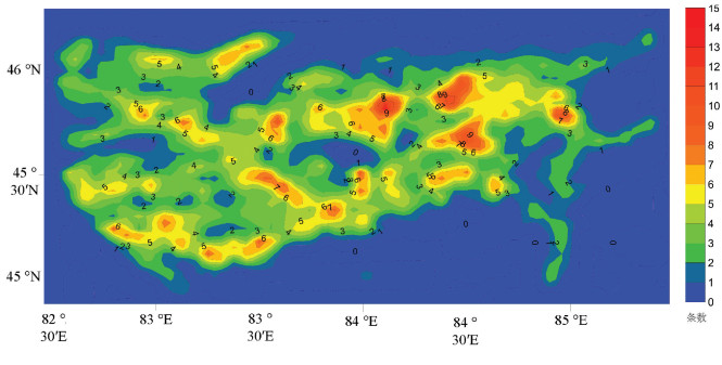
Figure 10.
Linear structural density contour map of Western Junggar
-
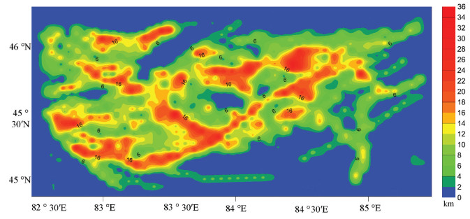
Figure 11.
Linear structural strength contour map of Western Junggar
-
Figure 12.
Distribution of main faults and tectonic lines interpreted by remote sensing in Western Junggar
-
Figure 13.
Types and orientation of partial structures in Western Junggar (modified from Zheng et al., 2008)