
| China Geological Survey Chinese Academy of Geological Sciences | Host |
| 科学出版社 | Publish |
| Citation: |
WANG Hui, QIN Xuwen, FAN Yuhai, YANG Jinzhong, JIN Moushun, ZHANG Shaopeng, LIAO Youyun, YANG Chen, CUI Sheng, HE Xiaolong, KUANG Jingshui, GUO Pengcheng. 2018. The application of high resolution remote sensing technology to ore-prospecting in Dahongliutan-Fulugou area of West Kunlun Mountains[J]. Geology in China, 45(6): 1289-1301. doi: 10.12029/gc20180617

|
The application of high resolution remote sensing technology to ore-prospecting in Dahongliutan-Fulugou area of West Kunlun Mountains
-
Abstract
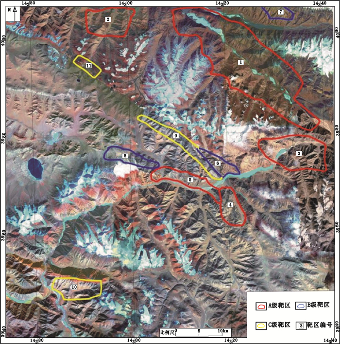
In this paper, with the Dahongliutan-Fulugou area of West Kunlun Mountains as a study case and by using WorldView-2 remote sensing images as major data source, the authors compiled standard image map and adopted method of image enhancement to protrude the information of ore-controlling factors and mineralization. The interpretation of remote sensing for mineral resources was carried out. By using ASTER data the authors conducted alteration anomaly information extraction, with the addition of a proper amount of field investigation verification. The authors finally found four great prospecting potential mineralization belts, which included one granite pegmatite belt (including rare metals) and stratabound iron polymetallic mineralization zone in Dahongliutan, one hydrothermal vein-type iron, lead, silver, copper mineralization zone and four stratabound siderite-hematite mineralization belts containing copper-lead-zinc-silver in Fulugou. Through a comprehensive analysis of remote sensing, 11 remote sensing prospecting targets were delineated, which included 5 A-class, 3 B-class and 3 C-class, and this can be used as the basis for deploying mineral resources survey project and exploration and evaluation of mineral resources. Therefore, the high score remote sensing technology deserves further promotion and application in similar areas of West Kunlun, because it can realize the rapid breakthrough of ore prospecting work in the mineral geological survey.
-

-
References
Bureau of Geology and Mineral Resources of Xinjiang Autonomous Region.1993. Regional Geology of Xinjiang Autonomous Region[M]. Beijing:Geological Publishing House, 1-841(in Chinese). Chen Ling, Zhang Wei, Zhou Yan, Liu Wei, Chen Wei. 2012. Application of high-resolution remote sensing images to searching for sedimentary-metamorphic type iron deposits in the Taxkorgan Area, Xinjiang[J]. Geology and Exploration, 48(5):1039-1048(in Chinese with English abstract). Chen Shoujian, Li Rongshe, Ji Wenhua, Zhao Zhenming, Meng Yong, Shi Bingde. 2007. The deposition characteristics and tectonoplaeogeographic environment of Kunlun orogenic belt in late devonian[J]. Geotectonicaet Metallogenia, 31(1):44-51(in Chinese with English abstract). Cheng Yuqi.1994. Outline to the Regional Geology of China[M]. Beijing:Geological Publishing House, 1-200(in Chinese). Cui Jiantang, Bian Xiaowei, Wang Juchuan, Yang Kejian, Zhu Haiping, Zhang Junliang.2006. Discovery of an unconformity between the Lower Silurian and Middle Devonian in the Tianshuihu area, southern Kangxiwar, West Kunlun, China[J]. Geological Bulletin of China, 25(12):1437-1440(in Chinese with English abstract). Gao Xiaofeng, Xiao Peixi, Kang Lei, Zhu Haiping, Guo Lei, Xi Rengang, Dong Zengchan.2013.Origin of the volcanic rocks from the Ta'axi region, Taxkorgan, Xinjiang and its geological significance[J]. Earth Science-Journal of China University of Geosciences, 38(6):1169-1182 (in Chinese with English abstract). doi: 10.3799/dqkx.2013.116 Geng Xinxia, Yang Jianmin, Zhang Yujun, Yao Fojun. 2008. The application of ASTER Remote Sensing Data for extraction of alteration anomalies information in shallow overburden area-a case study of the Baoguto porphyry copper deposit intrusion in Western Junggar, Xinjiang[J]. Geological Review, 54(2):184-191(in Chinese with English abstract). Hou Zengqian, Song Yucai, Li Zheng, Wang Zhaolin, Yang Zhiming, Yang Zhusen, Liu Yingchao, Tian Shihong, He Longqing, Chen Kaixu, Wang Fuchun, Zhao Chengxiang, Xue Wanwen, Lu Haifeng. 2008. Thrust-controlled sediments-hosted Pb-Zn-AgCu deposits in eastern and northern margins of Tibetan orogenic belt:Geological features and tectonic model[J]. Mineral Deposits, 27(2):123-144(in Chinese with English abstract). Jia Qunzi.1999. Massive Sulfide Copper Deposits of West Kunlun, Xinjiang[M]. Beijing:Geological Publishing House, 1-100(in Chinese). Jiang Chunfa, Yang Jingsui, Feng Binggui. 1992. Opening and Closing Structure of Kunlun[M]. Beijing:Geological Publishing House, 161-168 (in Chinese). Jiang Chunfa, Zhu Songnian.1992. Introduction to tectonic migration theory[J]. Acta Geoscientica Sinica. 25:1-14(in Chinese with English abstract). Jiang Chunfa.2002. Important geological problems and the research progress of the Central Orogenic Belt[J]. Regional Geology of China, 21(Z2):453-455(in Chinese with English abstract). Jin Moushun, Wang Hui, Qiao Gengbiao, Zhang Shaopeng.2014. The discovery of Heiqia Iron Mineralization Belt in West Kunlun by high resolution remote sensing technology and its geological significance[J]. Northwestern Geology, 47(4):221-226(in Chinese with English abstract). Li Boqin, Yao Jianxin, Gao Lianda, Bian Xiaowei, Yin Zongyi, Cui Jiantang, Chen Wenxi. 2007. Age and source regions of the Wenquangou Group in the Mazhar-Kangxiwar area, West Kunlun Mountains[J]. Geological Bulletin of China, 26(4):457-465(in Chinese with English abstract). Li Wenyuan, Zhang Zhaowei, Gao Yongbao.2008. The important mineralization events and tectonic response of Qinling, Qilian and Kunlun orogenic belts[C]//Chen Yuchuan, Xue Chunji, Zhang Changqing. Endeavoring Deep Marching West Scaning WorldSymposium of the Ninth Mineral Deposit Conference in China. Beijing:Geological Publishing House, 15 -16 (in Chinese). Li Wenyuan.2015. Metallogenic geological characteristics and newly discovered orebodies in Northwest China[J]. Geology in China, 42(3):365-380(in Chinese with English abstract). Lu Songnian, Li Huaikun, Chen Zhihong. 2003. Characteristics, sequence and ages of Neoproterozoic thermo-tectonic events between Tarim and Yangzi blocks-A hypothesis of Yangzi-Tarim connection[J]. Earth Science Frontiers, 2003, 10 (4):321-326(in Chinese with English abstract). Pan Yusheng, Zhou Weiming, Xu Ronghua, Wang Andong, Zhang Yuquan, Xie Yingwen, Chen Tingen, Luo Hui. 1996. Early Paleozoic geological features and evolution of the Kunlun Mountains[J]. Science in China(Series D), 26(4):302-307(in Chinese) Pan Yusheng. 1999. The formation and uplifting of the Qinghai Tibet Plateau[J]. Earth Science Frontiers, 6(3):153-163(in Chinese with English abstract). Pan Yusheng.1989. Tectonic division of Kunlun mountain[J]. Journal of Natural Resources, 4(3):196-203(in Chinese with English abstract). Pan Yusheng. 1994. The discovery and demonstration of the fifth suture zone in Qinghai-Tibet Plateau[J]. Chinese Journal of Geophysics, 37 (2):184-192(in Chinese with English abstract). Ph Matte, P Tapponnier. 1995. Geology along the line from Yecheng to Shiquanhe and tectonic evolution of the region involved[J]. Acta Geologica Sinica, 8(2):119-133. Shang Dong. 2009. WorldView-2 high resolution satellite launch successfully[J]. Remote Sensing For Land & Resources, 20(4):109(in Chinese). Wang Runsheng, Xiong Shengqing, Nie Hongfeng, Liang Shuneng, Qi Zerong, Yang Jinzhong, Yan Baikun, Zhao Fuyue, Fan Jinghui, Tong Liqiang, Lin Jian, Gan Fuping, Chen Wei, Yang Suming, Zhang Ruijiang, Ge Daqing, Zhang Xiaokun, Zhang Zhenhua, Wang Pinqing, Guo Xiaofang, Li Li. 2011. Remote sensing technology and its application in geological exploration[J]. Acta Geologica Sinica, 85(11):1699-1742(in Chinese with English abstract). Wang Shulai, Wang Dongbo, Zhu Xinyou. 2000. Ore-searching prospecting analysis of gold(copper) deposits in the West Kunlun[J]. Contribution to Geology and Mineral Resources Research, 15(3):224-229 (in Chinese with English abstract). Wu Jianhua, Liu shuai. 2008.Introduction to Geotectonics and Outline of Chinese Earth Tectonics[M]. Beijing:Geological Publishing House (in Chinese). Xi'an institute of Geology and Mineral Resources. 2006. The Prospecting Potential of Mineral Resources in Northwest China[M]. Beijing:Geological Publishing House, 1-150 (in Chinese). Xu Zhiqin, Qi Xuexiang, Liu Fulai, Yang Jingsui, Wu Cailai, Zeng Linsen, Liang Fenghua. 2004. The Kangxiwar Caledonian Khondalite Series in West Kunlun, China, and its geological significance[J]. Acta Geologica Sinica, 78(6):733-743(in Chinese with English abstract). Yang Jinzhong, Fang Hongbin, Zhang Yujun, Chen Wei. 2003. Remote sensing anomaly extraction in important metallogenic belts of western China[J]. Remote Sensing for Land and Resources, 15(3):50-53 (in Chinese with English abstract). Yang Jinzhong, Zhao Yuling. 2015. Technical features of remote sensing and its application in the geological survey and mineral resources survey[J]. Mineral Exploration, 6(5):529-534 (in Chinese with English abstract). Yang Kerning. 1994. Tectonic evolution of continental margin on the West Kunlun and type of southwestern Tarim Basin[J]. Geological Review, 1:9-18 (in Chinese with English abstract). Yao Jianxin, Xiao Xuchang, Gao Lianda, Han FangLin, Cui JianTang, Peng HaiLian, Ji ZhanSheng, Wu GuiChun.2006. Silurian acritarchs and chitinozoans in Wenquangou Group from The West Kunlun region[J]. Acta Palaeontologica Sinica, 45 (4):528-532(in Chinese with English abstract). Zhang Ce, Peng Lihong, Wang Bing, Zhang En, Fu Lihua, Wei Benzan, Jie Wenhui. 2015. Application of WorldView-2 remote sensing image in the exploration of the volcano-sedimentary metamorphic type iron deposits in the Dimunalike area, Xinjiang[J]. Mineral Exploration, 6(5):523-528(in Chinese with English abstract). Zong Wenming, Gao Linzhi, Ding Xiaozhong, Pang Weihua.2010. Characteristics of nanhuan diamictite (tillite) and stratigraphic correlation in the Southwestern Margin of Tarim Basin[J]. Geology in China, 37(4):1183-1190(in Chinese with English abstract). 陈玲, 张微, 周艳, 刘伟, 陈微. 2012.高分辨率遥感影像在新疆塔什库尔干地区沉积变质型铁矿勘查中的应用[J].地质与勘探, 48(5):1039-1048. 陈守建, 李荣社, 计文化, 赵振明, 孟勇, 史秉德. 2007.昆仑造山带晚泥盆世沉积特征及构造古地理环境[J].大地构造与成矿学, 31(1):44-51. doi: 10.3969/j.issn.1001-1552.2007.01.006 程裕淇. 1994.中国区域地质概论[M].北京:地质出版社, 1-200. 崔建堂, 边小卫, 王炬川, 杨克俭, 朱海平, 张俊良.2006.西昆仑康西瓦南部甜水湖一带下志留统与中泥盆统不整合界面的发现[J].地质通报, 2006, 25(12):1437-1440. doi: 10.3969/j.issn.1671-2552.2006.12.012 高晓峰, 校培喜, 康磊, 朱海平, 过磊, 奚仁刚, 董增产.2013.新疆塔什库尔干塔阿西一带火山岩成因及地质意义[J].地球科学——中国地质大学学报, 38 (6):1169-1182. 耿新霞, 杨建民, 张玉君, 姚佛军.2008. ASTER数据在浅覆盖区蚀变遥感异常信息提取中的应用——以新疆西准噶尔包古图斑岩铜矿岩体为例[J].地质论评, 54(2):184-191. doi: 10.3321/j.issn:0371-5736.2008.02.005 侯增谦, 宋玉财, 李政, 王召林, 杨志明, 杨竹森, 刘英超, 田世洪, 何龙清, 陈开旭, 王富春, 赵呈祥, 薛万文, 鲁海峰. 2008.青藏高原碰撞造山带Pb-Zn-Ag-Cu矿床新类型:成矿基本特征与构造控矿模型[J].矿床地质, 27(2):123-144. doi: 10.3969/j.issn.0258-7106.2008.02.001 贾群子. 1999.新疆西昆仑块状硫化物铜矿床[M].北京:地质出版社, 1-100. 姜春发, 杨经绥, 冯秉贵. 1992.昆仑开合构造[M].北京:地质出版社, 161-168. 姜春发, 朱松年. 1992.构造迁移论概述[J].中国地质科学院院报, 25:1-14. 姜春发. 2002.中央造山带几个重要地质问题及其研究进展(代序)[J].地质通报, 21(Z2):453-455. 金谋顺, 王辉, 乔耿彪, 张少鹏. 2014.利用高分遥感技术发现西昆仑黑恰铁矿矿化带及其地质意义[J].西北地质, 47(4):221-226. doi: 10.3969/j.issn.1009-6248.2014.04.023 李博秦, 姚建新, 高联达, 边小卫, 尹宗义, 崔建堂, 陈文西. 2007.西昆仑麻扎-康西瓦一带温泉沟群的形成时代及物源区分析[J].地质通报, 26(4):457-465. doi: 10.3969/j.issn.1671-2552.2007.04.012 李文渊, 张照伟, 高永宝. 2008.秦祁昆造山带重要成矿事件及其构造演化响应[C]//陈毓川, 薛春纪, 张长青.主攻深部挺进西部放眼世界——第九届全国矿床会议论文集.北京: 地质出版社, 15-16. 李文渊.2015.中国西北部成矿地质特征及找矿新发现[J].中国地质, 42(3):365-380. doi: 10.3969/j.issn.1000-3657.2015.03.001 陆松年, 李怀坤, 陈志宏.2003.塔里木与扬子新元古代热-构造事件特征、序列和时代——扬子与塔里木连接(YZ-TAR)假设[J].地学前缘, 10(4):321-326. doi: 10.3321/j.issn:1005-2321.2003.04.001 潘裕生, 周伟明, 许荣华, 王东安, 张玉泉, 谢应雯, 陈挺恩, 罗辉. 1996.昆仑山早古生代地质特征与演化[J].中国科学(D辑), 26(4):302-307. doi: 10.3321/j.issn:1006-9267.1996.04.003 潘裕生. 1999.青藏高原的形成与隆升[J].地学前缘, 6(3):153-163. doi: 10.3321/j.issn:1005-2321.1999.03.015 潘裕生.1989.昆仑山区构造区划初探[J].自然资源学报, 4(3):196-203. doi: 10.3321/j.issn:1000-3037.1989.03.002 潘裕生.1994.青藏高原第五缝合带的发现与论证[J].地球物理学报, 37(2):184-192. doi: 10.3321/j.issn:0001-5733.1994.02.006 尚东. 2009. WorldView-2高分辨卫星发射成功[J].国土资源遥感, 20(4):109. 王润生, 熊盛青, 聂洪峰, 梁树能, 齐泽荣, 杨金中, 闫柏琨, 赵福岳, 范景辉, 童立强, 林键, 甘甫平, 陈微, 杨苏明, 张瑞江, 葛大庆, 张晓坤, 张振华, 王品清, 郭小方, 李丽.2011.遥感地质勘查技术与应用研究[J].地质学报, 85(11):1699-1742. 王书来, 汪东波, 祝新友.2000.新疆西昆仑金(铜)矿找矿前景分析[J].地质找矿论丛, 15(3):224-229. doi: 10.3969/j.issn.1001-1412.2000.03.004 巫建华, 刘帅. 2008.大地构造学概论与中国大地构造学纲要[M].北京:地质出版社, 2008. 西安地质矿产研究所.2006.西北地区矿产资源找矿潜力[M].北京:地质出版社, 1-150. 新疆自治区地质矿产局.1993.新疆自治区区域地质志[M].北京:地质出版社, 1-841. 许志琴, 戚学祥, 刘福来, 杨经绥, 吴才来, 曾令森, 梁凤华.2004.西昆仑康西瓦加里东期孔兹岩系及地质意义[J].地质学报, 78(6):733-743. doi: 10.3321/j.issn:0001-5717.2004.06.003 杨金中, 方洪宾, 张玉君, 陈薇. 2003.中国西部重要成矿带遥感找矿异常提取的方法研究[J].国土资源遥感, 15(3):50-53. doi: 10.3969/j.issn.1001-070X.2003.03.012 杨金中, 赵玉灵.2015.遥感技术的特点及其在地质矿产调查中的作用[J].矿产勘查, 6(5):529-534. doi: 10.3969/j.issn.1674-7801.2015.05.006 杨克明. 1994.论西昆仑大陆边缘构造演化及塔里木西南盆地类型[J].地质论评, 1:9-18. doi: 10.3321/j.issn:0371-5736.1994.01.002 姚建新, 肖序常, 高联达, 韩芳林, 崔建堂, 彭海练, 纪占胜, 武桂春. 2006.西昆仑地区志留系温泉沟群的疑源类和几丁虫[J].古生物学报, 45(4):528-532. doi: 10.3969/j.issn.0001-6616.2006.04.009 宗文明, 高林志, 丁孝忠, 庞维华. 2010.塔里木盆地西南缘南华纪冰碳岩特征与地层对比[J].中国地质, 37(4):1183-1190. doi: 10.3969/j.issn.1000-3657.2010.04.032 -
Access History
Figures(8)
Tables(3)

Export File
Citation
WANG Hui, QIN Xuwen, FAN Yuhai, YANG Jinzhong, JIN Moushun, ZHANG Shaopeng, LIAO Youyun, YANG Chen, CUI Sheng, HE Xiaolong, KUANG Jingshui, GUO Pengcheng. 2018. The application of high resolution remote sensing technology to ore-prospecting in Dahongliutan-Fulugou area of West Kunlun Mountains[J]. Geology in China, 45(6): 1289-1301. doi: 10.12029/gc20180617
Format
Content
 DownLoad:
-
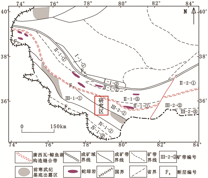
Figure 1.
The division of metallogenic belt in the study area
-
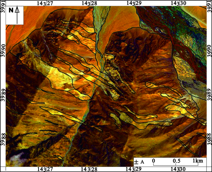
Figure 2.
The high resolution remote sensing characteristics of granite pegmatite veins
-
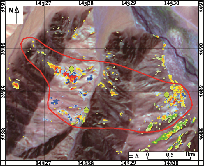
Figure 3.
ASTER anomaly map of granitic pegmatite veins development zone
-
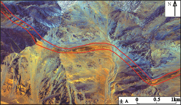
Figure 4.
The characteristics of high resolution remote sensing of iron polymetallic mineralization belt (local) in the Dahonglitan area
-
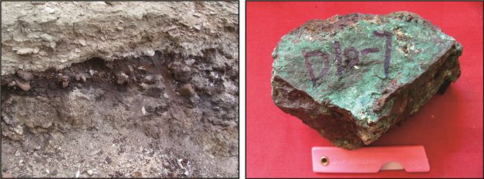
Figure 5.
The field outcrop of iron polymetallic mineralization and photo of hematite with copper in the Dahonglitan area
-
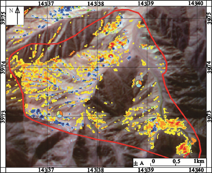
Figure 6.
ASTER anomaly map of silver-galena zone in the east of Fulugou
-
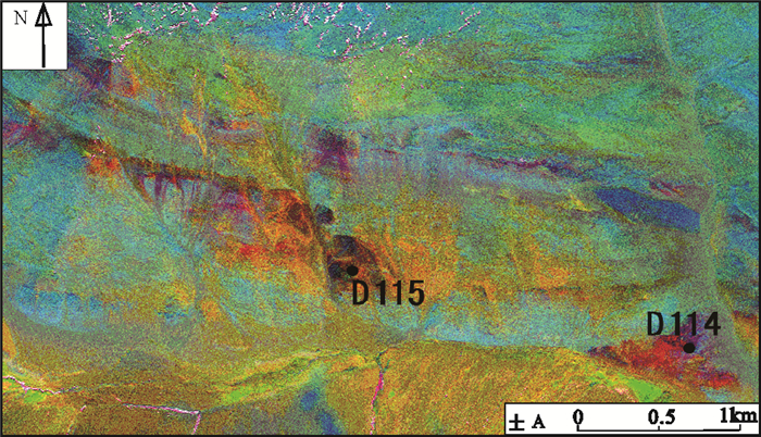
Figure 7.
The characteristics of WorldView−2 high resolution remote sensing of iron ore belt (local)
-
Figure 8.
The map of remote sensing prospecting target areas in the study area