
| China Geological Survey Chinese Academy of Geological Sciences | Host |
| 科学出版社 | Publish |
| Citation: |
SUN Yongbin, WANG Ruijun, WEI Benzan, WANG Bing, DONG Shuangfa, LI Cunjin, LI Mingsong. 2018. The application of hyperspectral remote sensing ground-air integrated prediction method to the copper gold deposit prospecting in Kalatag area, Xinjiang[J]. Geology in China, 45(1): 178-191. doi: 10.12029/gc20180115

|
The application of hyperspectral remote sensing ground-air integrated prediction method to the copper gold deposit prospecting in Kalatag area, Xinjiang
-
Abstract
Kalatag area of Xinjiang is located in the east Tianshan metallogenic belt, where mineral resources are abundant, and copper, gold and polymetallic ore deposits have great prospecting potential. Copper and gold mineralization and surface mineralized alteration phenomena are obvious, and limonite mineralization + jarosite + sericitization assemblage has formed abnormal spectral reflectance characteristics, which are favorable for the utilization of hyperspectral remote sensing ground-air integrated prediction method to detect copper and gold mineralization alteration information. In this paper, the authors carried out air high spectrum and ground spectrum in search for copper gold polymetallic deposits. HyMap aviation imaging spectrometer and FieldSpec Pro FR spectrometer were adopted and, as a result, HyMap aviation high spectral resolution data, ground quasi-synchronization calibration data and ground hyperspectral data were obtained in the study area, whereas extracting and filtering were conducted based on HyMap aerial hyperspectral image of metallogenicl favorability alteration information. On such a basis, the air-ground hyperspectral comprehensive analysis was made for the Hongshan copper and gold deposit in the study area and, in combination with the geological background of the deposit, a hyperspectral remote sensing ground-air integrated prospecting model was established for the Hongshan copper gold deposit. On the basis of comparison and analysis, two prospecting targets were delineated. The application of hyperspectral remote sensing ground-air integrated prediction method in the study area shows a good application effect.
-

-
References
Clack R N, King T V V, Klejwa M, Swayyze G A, Veego N. 1990. High spectral resolution reflectance spectroscopy of minerals[J].Journal of Geophysical Research, 95:12653-12680. doi: 10.1029/JB095iB08p12653 Clark R N, King T V V, Klejwa M. 1990. High spectral resolution reflectance spectroscopy of minerals[J].J. Geophys. Res., 95:12653-12680. doi: 10.1029/JB095iB08p12653 Campbell J b, Wyname R H. 2011. Introduction to Remote Sensing[M].Fifth Edition.New York:Guilford Press:3-28. Dong Chengwei. 2013. Carla's Mining Area and Magnetic Characteristics and Prospecting Prediction[D]. Kunming University of Science and Technology(in Chinese with English abstract). Du Xiaodi, Tang Yue, Liu Dechang, Li Zhao, Wang Haida. 2015. The application of aerial hyperspectral technology to the geological survey for oil and gas in the East Junggar Basin[J]. Geology in China, 42(1):275-287(in Chinese with English abstract). Everett J R, Jengo C J, Staskowski R J. 2002. Remote and GIS enable future exploration success[J].World Oil, 223(11):59-65. Guo Defang. 1995. Direct searching for oil and gas by remote sensing technology[J]. Acta Petrolei Sinica, 16(4):9-16(in Chinese with English abstract). Gan Fuping, Wang Runsheng, Ma Ainai. 2003. Based on the characteristic band of hyperspectral remote sensing spectrum identification of minerals[J]. Earth Science——Journal of China University of Geosciences, 10(2):445-454(in Chinese with English abstract). Gan Fuping, Wang Runsheng, Ma Ainai, Zhang Zonggui, Li Mengxia.2003. Integration of remote sensing geology information extraction and mineral remote sensing geological analysis model[J]. Journal of Remote Sensing, 7(3):207-213(in Chinese with English abstract). Liu Yanjun, Jin Lifang. 1993. Evaluation of buried oil-controlling structure in loess region by remote sensing method[J]. Remote Sensing of environment China, 8(4):278-285(in Chinese with English abstract). Liao Chonggao, Yang Wunian, Xu Ling, Pu Guoliang. 2002.Metallogenic prediction in the comprehensive analysis of remote sensing and geological anomaly-in orchid basin as an example[J]. Geology in China, 29(4):416-420(in Chinese with English abstract). Lian Changyun, Zhang Ge, Yuan Chunhua, Yang Kai. 2005. Shortwave mineral thermal infrared spectrum measurement technology in the application of hydrothermal alteration mineral mapping-huts with porphyry copper deposit as an example[J]. Geology in China, 32(3):483-495(in Chinese with English abstract). Liu Shengwei, Gan Fuping, Yan Bokun, Yang Suming, Wang Runsheng, Wang Qinghua, Tang Panke. 2006. Imaging spectroscopy in typical alteration mineral identification and the application of the mapping[J]. Geology in China, 2006(2):178-186(in Chinese with English abstract). Liu Yingfan, Chen Jianping, Hao Junfeng, Liang Lixin, Cui Laiwang. 2012. Zhu raza ga in Inner Mongolia region mineralization remote sensing information extraction and metallogenic prediction research[J]. Geology in China, 39(4):1062-1068(in Chinese with English abstract). Lu Yan. 2014. Airborne HyMap Hyperspectral Data Acquisition and Processing the Work Report[R] (in Chinese). Liu Dechang, Qiu Junting, Tian Feng, Sun Yu. 2015. Regional orecontrolling fault zone of the aerial hyperspectral remote sensing technology research-the black stone mountain-take down deep fault belt as an example[J]. Geology and Exploration, 51(2):366-375in Chinese with English abstract). Li Zhizhong, Wang Daming, Liu Dechang, Liu Yinnian, Zhao Huijie, Dang Fuxing. 2015. Hyperspectral remote sensing technology and resources exploration progres[J]. Earth Science-Journal of China University of Geosciences, 40(8):1287-1294(in Chinese with English abstract). doi: 10.3799/dqkx.2015.108 Povarennykh A S. 1978. The Use of Infrared Spectra for the Determination of Minerals.Am.Mineral. 63:956-959. Qian Jianping, Wu Guihua, Chen Hongyi. 2012. Modern remote sensing technology in the application of the geological prospecting[J]. Contributions to Geology and Mineral Resources Research, 27(3):355-360(in Chinese with English abstract). Sabins F F. 1999. Remote sensing for mineral exploration[J]. OreGeology Reviews, 14:157-183. Shu Jiong, Wang Qiang, Sun Juan. 2006. Hyperspectral remote sensing application researchm[J]. Journal of East China Normal University, 2006 (4):1-10(in Chinese with English abstract). Tan Kelong, Wan Yuqing, Wang Xiaofeng, Sun Shunxin, Chen Xiangling. 2012. Based on the study on the method of remote sensing technology of coal exploration[J]. Geology in China, 39(1):218-227(in Chinese with English abstract). Wang Jingbin, Wang Yuwang, He Zhijun. 2006. East tianshan tectonic evolution of metallogenic tracer[J]. Geology in China, 33(3):461-469(in Chinese with English abstract). Wang Runsheng, Gan Fuping, Yan Bokun, Yang Suming, Wang Qinghua. 2010. Mineral mapping hyperspectral technology and applied research[J]. Remote Sensing for Land & Resources, 21(1):1-13 (in Chinese with English abstract). Wang Runsheng, Xiong Shengqing, Nie Hongfeng, Liang Shuneng, Qi Zerong, Yang Jinzhong, Yan Bokun, Zhao Fuyue, Fan Jinghui, Tong Liqiang, Lin Jian, Gan Fuping, Chen Wei, Yang Suming, Zhang Ruijiang, Ge Daqing, Zhang Xiaokun, Zhang Zhenhua, Wang Pinqing, Guo Xiaofang, Li Li. 2011. Remote sensing geology exploration technology and applied research[J]. Acta Geologica Sinica, 85(11):1700-1743(in Chinese with English abstract). Wang Ruijun, Niu Haiwei, Sun Yongbin, et al. 2014. Key Areas in Xinjiang Aviation High Phase Spectrum Survey and Prospecting Prediction Technology Research Report[R] (in Chinese). Xu Yingxia, Qin Kezhang, Ding Kuishou, Li Jinxiang, Miao Yu, Fang Tonghui, Chen Xingwang, Li Daming, Luo Xiuquan. 2008. East tianshan hongshan high sulfur type hypabyssal copper and gold deposits in low temperature:Mesozoic metallogenic oxidation K -Ar in Cenozoic, Ar-Ar chronology and its significance in ancient tectonic and paleoclimate evidence[J]. Acta Petrologica Sinica, 24(10):2371-2383(in Chinese with English abstract). Xu Yingxia, Qin Kezhang, Xu Xingwang, Ding Kuishou, Yu Shuyan, Fang Tonghui. 2010. East tianshan Carla tager metallogenic belt hongshan copper-gold deposit S isotopic features and metallogenic potential research[J]. Northwestern Geology, 43(4):279-284(in Chinese with English abstract). Yao fojun. 2006. Desert Gobi Area Metal Deposit Abnormal Spectrum Characteristics and Alteration of Remote Sensing Information Extraction Research and Application in the Evaluation of Mineral Resources[D]. Chinese Academy of Geological Sciences (in Chinese with English abstract). Zhu Zhenhai. 1994. Hydrocarbon micro-seepage theory and oil & gasreservoir detecting by remote sensing[J]. Remote Sensing Technology and Application, 9(1):1-10(in Chinese with English abstract). 董承维. 2013. 卡拉塔格矿区重磁特征及找矿预测[D]. 昆明: 昆明理工大学. http://cdmd.cnki.com.cn/Article/CDMD-10674-1013345022.htm 杜小弟, 唐跃, 刘德长, 李昭, 王海达. 2015.航空高光谱探测技术在准噶尔盆地东部地区油气调查中的应用[J].中国地质, 42(1):275-287. 郭德方. 1995.遥感技术直接找油[J].石油学报, 16(4):9-16. doi: 10.7623/syxb199504002 甘甫平, 王润生, 马蔼乃. 2003.基于特征谱带的高光谱遥感矿物谱系识别[J].地球科学, 10(2):445-454. 甘甫平, 王润生, 马蔼乃, 张宗贵, 李孟霞. 2003.遥感地质信息提取集成与矿物遥感地质分析模型[J].遥感学报, 7(3):207-213. doi: 10.11834/jrs.20030308 刘燕君, 金丽芳. 1993.遥感方法对黄土地区隐伏控油构造的评价[J].环境遥感, 8(4):278-285. 廖崇高, 杨武年, 徐凌, 濮国梁. 2002.成矿预测中遥感与地质异常的综合分析-以兰坪盆地为例[J].中国地质, 29(4):416-420. 连长云, 章革, 元春华, 杨凯. 2005.短波热红外光谱矿物测量技术在热液蚀变矿物填图中的应用——以土屋斑岩铜矿床为例[J].中国地质, 32(3):483-495. 刘圣伟, 甘甫平, 闫柏琨, 杨苏明, 王润生, 王青华, 唐攀科. 2006.成像光谱技术在典型蚀变矿物识别和填图中的应用[J].中国地质, 2006(2):178-186. 刘颖璠, 陈建平, 郝俊峰, 梁丽新, 崔来旺. 2012.内蒙古朱拉扎嘎地区成矿遥感信息提取及成矿预测研究[J].中国地质, 39(4):1062-1068. 卢燕. 2014. 机载HyMap高光谱数据获取和处理工作报告[R]. 北京: 中国有色金属矿产勘查中心. 刘德长, 邱骏挺, 田丰, 孙雨. 2015.区域控矿断裂带的航空高光谱遥感技术研究——以黑石山-花牛山深大断裂带为例[J].地质与勘探, 51(2):366-375. 李志忠, 汪大明, 刘德长, 刘银年, 赵慧洁, 党福星. 2015.高光谱遥感技术及资源勘查应用进展[J].地球科学, 40(8):1287-1294. 钱建平, 伍贵华, 陈宏毅. 2012.现代遥感技术在地质找矿中的应用[J].地质找矿论丛, 27(3):355-360. 束炯, 王强, 孙娟. 2006.高光谱遥感的应用研究[J].华东师范大学学报, 2006(4):1-10. 谭克龙, 万余庆, 王晓峰, 孙顺新, 陈香菱. 2012.基于遥感技术的煤炭勘查方法研究[J].中国地质, 39(1):218-227. 王京彬, 王玉往, 何志军. 2006.东天山大地构造演化的成矿示踪[J].中国地质, 33(3):461-469. 王润生, 甘甫平, 闫柏琨, 杨苏明, 王青华. 2010.高光谱矿物填图技术与应用研究[J].国土资源遥感, 21(1):1-13. doi: 10.6046/gtzyyg.2010.01.01 王润生, 熊盛青, 聂洪峰, 梁树能, 齐泽荣, 杨金中, 闫柏琨, 赵福岳, 范景辉, 童立强, 林键, 甘甫平, 陈微, 杨苏明, 张瑞江, 葛大庆, 张晓坤, 张振华, 王品清, 郭小方, 李丽. 2011.遥感地质勘查技术与应用研究[J].地质学报, 85(11):1700-1743. 王瑞军, 牛海威, 孙永彬. 2014. 新疆重点地区航空高光谱调查与找矿预测技术研究阶段成果报告[R]. 北京: 地调局高光谱会议. 许英霞, 秦克章, 丁奎首, 李金祥, 缪宇, 方同辉, 徐兴旺, 李大明, 罗修泉. 2008.东天山红山高硫型浅成低温铜-金矿床:中生代成矿与新生代氧化的K-Ar、Ar-Ar年代学证据及其古构造和古气候意义[J].岩石学报, 24(10):2371-2383. 许英霞, 秦克章, 徐兴旺, 丁奎首, 于淑艳, 方同辉. 2010.东天山卡拉塔格成矿带红山铜-金矿床S同位素特征及成矿潜力研究[J].西北地质, 43(4):279-284. 姚佛军. 2006. 荒漠戈壁区金属矿床波谱特征和蚀变遥感异常信息提取研究及在矿产资源评价中的应用[D]. 北京: 中国地质科学院. http://www.wanfangdata.com.cn/details/detail.do?_type=degree&id=Y932089 朱振海. 1994.油气藏烃类微渗漏理论及遥感油气资源探测的机理研究[J].遥感技术与应用, 9(1):1-10. doi: 10.11873/j.issn.1004-0323.1994.1.1 -
Access History
Figures(11)
Tables(3)

Export File
Citation
SUN Yongbin, WANG Ruijun, WEI Benzan, WANG Bing, DONG Shuangfa, LI Cunjin, LI Mingsong. 2018. The application of hyperspectral remote sensing ground-air integrated prediction method to the copper gold deposit prospecting in Kalatag area, Xinjiang[J]. Geology in China, 45(1): 178-191. doi: 10.12029/gc20180115
Format
Content
 DownLoad:


-
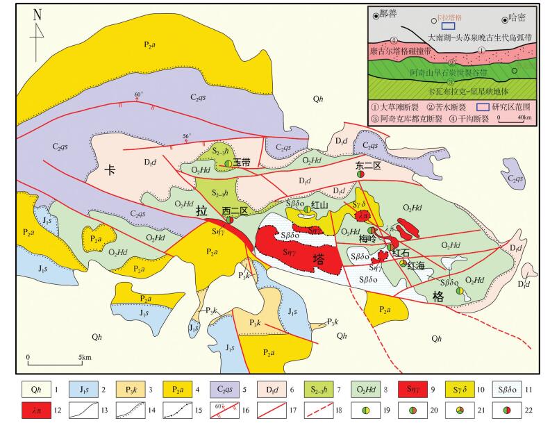
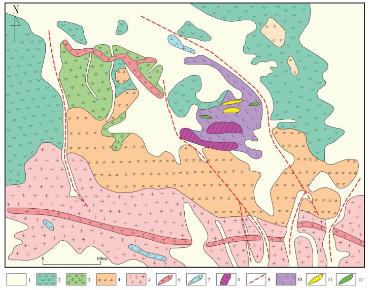
Figure 1.
Geological map of Kalatag area in Xinjiang
-
Figure 2.
Black and white cloth quasi-synchronization calibration spectra curve
-
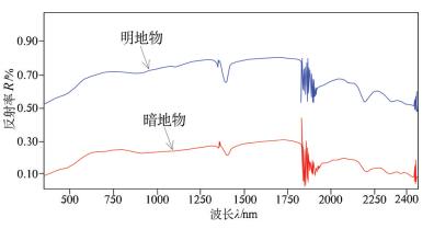
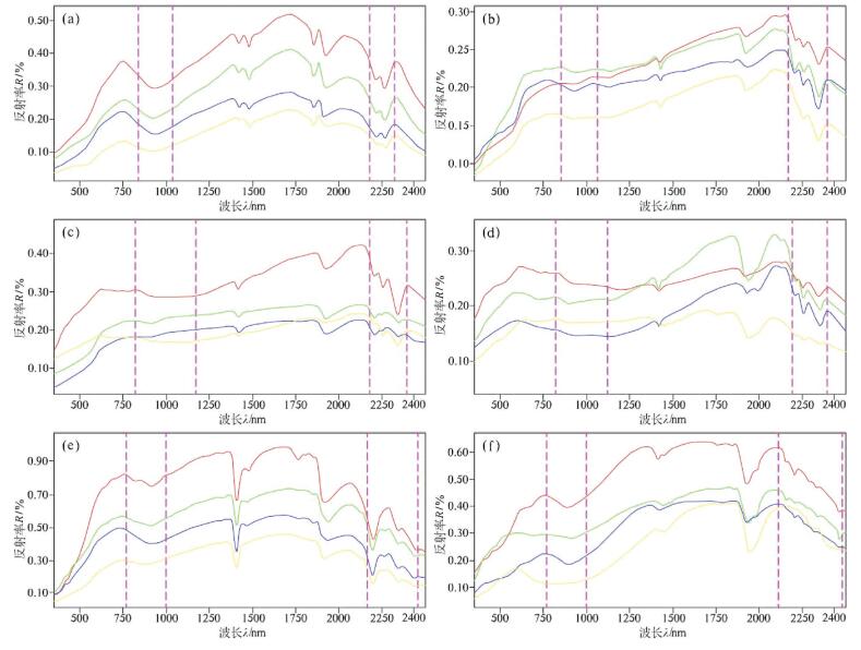
Figure 3.
Spectral curve features of light and shade ground quasi-synchronization calibration
-
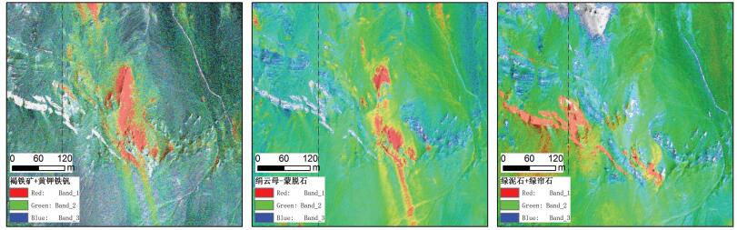
Figure 4.
HyMap aviation hyperspectral alteration mineral abundance map of Kalatag area in Xinjiang
-
Figure 5.
Geological map of the Hongshan Cu-Au deposit (after Wang, 2006)
-
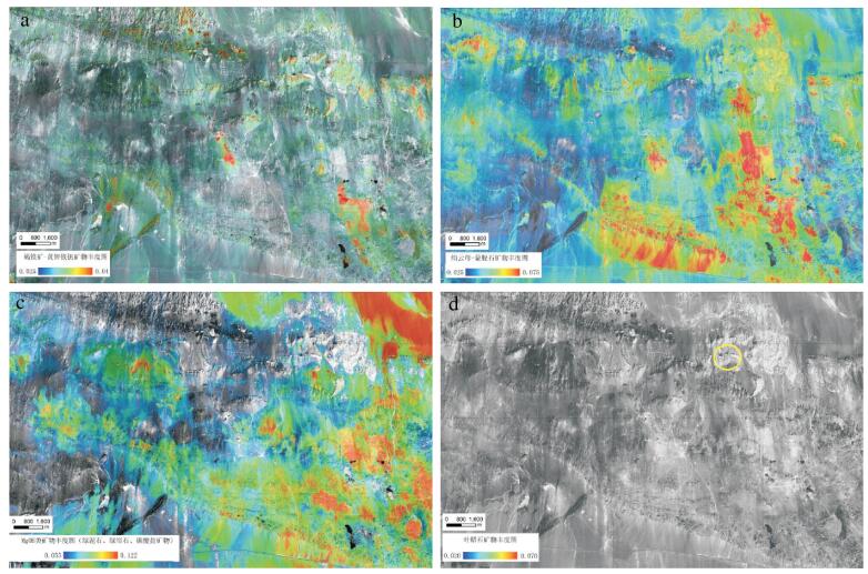
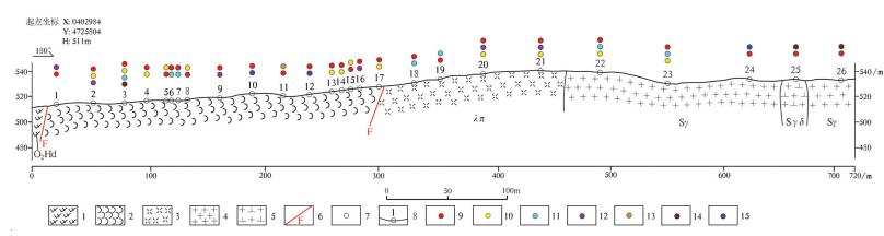
Figure 6.
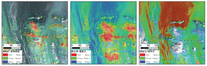
HyMap aviation high spectrum mineralization favorable alteration mineral distribution of the Hongshan copper gold deposit
-
Figure 7.
Surface hyperspectral alteration mineral distribution along geological section in the Hongshan copper gold orefield
-
Figure 8.
Comparison diagram of various lithology spectral curves from the Hongshan copper gold deposit and peripheral areas
-
Figure 9.
Favorable ore-prospecting optimization segments in Kalatag area of Xinjiang
-
Figure 10.
I−1 alteration mineral abundance map of favorable ore-prospecting segment
-
Figure 11.
I−2 alteration mineral abundance map of favorable ore-prospecting segment