
| China Geological Survey Chinese Academy of Geological Sciences | Host |
| 科学出版社 | Publish |
| Citation: |
PANG Jianfeng, DING Xiaozhong, HAN Kunying, ZENG Yong, CHEN Anshu, ZHANG Yanling, ZHANG Qinghe, YAO Dongsheng. 2017. The National 1: 1000000 Geological Map Spatial Database[J]. Geology in China, 44(S1): 8-18. doi: 10.12029/gc2017Z102

|
The National 1: 1000000 Geological Map Spatial Database
-
Abstract
The People's Republic of China 1:1000000 digital geological map database is based on uniform standards and requirements for the preparation of a thematic digital geological map. The geological map is based on comprehensive research, and fully absorbs the new achievements and new data of geological survey in recent years, making use of new technology, new theory and new methodology. Based on the chronology of the stratigraphic units and the representations of the rock strata, the intrusive rocks are further represented by the method of "lithology plus dating", which further improves the research degree of basic geology. The geological map database is rich in information with about 1.2 GB, having:rock stratigraphy units 5347 illustrations; intrusion "lithology plus era" unit 1780 cases; inter-provincial important fault 93; 558 important faults in the provinces (autonomous regions and municipalities); 1545 (group) of isotopic age data; and 382 representative holes. All the geometric elements of surface elements and line elements, isotopic age and drillings have established corresponding attributes, with adjacent maps between the map processing, map instructions and metadata are prepared. The database uses a unified linear library, symbol library, color library, the mapping process all using the MapGIS6.5 platform computer-aided map, plotting high precision, good quality, meeting design requirements to produce 64 national maps with four Area of the work of the method, the final unified system made. The digital geological map is the most complete and the latest 1:1000000 geological map in China, being the first result of China's first such digital geological map using GIS technology, which fully reflects the characteristics of China's geological structure and the current new level of geological research.
-
Keywords:
- 1:1000000 digital geological map /
- spatial database /
- MapGIS
-

-
References
Asch K.Under construction:the geological GIS of the 1:5 000 000 international geological map of Europe and adjacent areas[J].Episodes, 2001, 24(3):201-204. Bouysse P, Mendel V, Munschy M, et al.A new CGMW map:The structural map of the Indian Ocean:An attempt at ocean cartography[J].Episodes, 2004, 26(2):199-202. 韩坤英, 丁孝忠, 范本贤, 马丽芳, 剧远景.2005.MapGIS在建立地质图数据库中的应用[J].地球学报, 26(6):587-590. 韩坤英, 丁孝忠, 范本贤, 耿树方, 剧远景.2005.基于GIS的区域地质编图方法[J].中国地质, 32(4):713-717. 李廷栋.2007.国际地质编图现状及发展趋势[J].中国地质, 34(2):206-211. 张庆合, 曹邦功, 姜兰.2002.1:50万地质图数据库的研建[J].中国地质, 29(2):208-212. 万常选, 廖国琼, 吴京慧, 刘喜平.2009.数据库系统原理与设计[M].北京:清华大学出版社, 1-44.587-590. 李廷栋.2007.国际地质编图现状及发展趋势[J].中国地质, 34(2):206-211. 张庆合, 曹邦功, 姜兰.2002.1:50万地质图数据库的研建[J].中国地质, 29(2):208-212. Asch K.2001.Under construction:the geological GIS of the 1:5000000 international geological map of Europe and adjacent areas[J].Episodes, 24(3):201-204. Bouysse P, Mendel V, Munschy M, Segoufin J.2004.A new CGMW map:The structural map of the Indian Ocean:An attempt at ocean cartography[J].Episodes, 26(2):199-202. Han Kunying, Ding Xiaozhong, Fan Benxian, Geng Shufang, Ju Yuanjing.2005.The application of MapGIS to the construction of geological map database[J].Acta Geoscientica Sinica, 26(6):587-590(in Chinese with English abstract). Han Kunying, Ding Xiaozhong, Fan Benxian, Geng Shufang, Ju Yuanjing.2005.Methods of regional geological map production based on GIS[J].Geology in China, 32(4):713-717(in Chinese with English abstract). Li Tingdong.2007.Status and development trend of geological map compilation in the world[J].Geology in China, 34(2):26-211(in Chinese with English abstract). Zhang Qinghe, Cao Banggong, Jiang Lan.2002.Development and construction of the 1:500 000 geological map database[J].Geology in China, 29(2):208-212(in Chinese with English abstract). -
Access History
Figures(4)
Tables(4)

Export File
Citation
PANG Jianfeng, DING Xiaozhong, HAN Kunying, ZENG Yong, CHEN Anshu, ZHANG Yanling, ZHANG Qinghe, YAO Dongsheng. 2017. The National 1: 1000000 Geological Map Spatial Database[J]. Geology in China, 44(S1): 8-18. doi: 10.12029/gc2017Z102
Format
Content
 DownLoad:
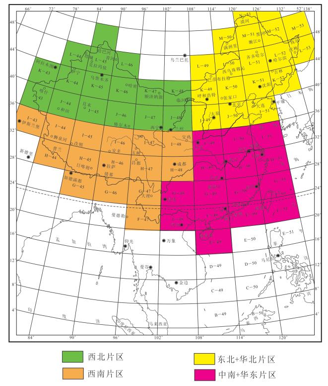
- Figure 1.
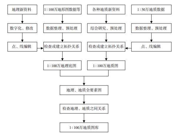
- Figure 2.
-
Figure 1.
Sheet index of 1:1000000 geological map of China and the division of working areas.
-
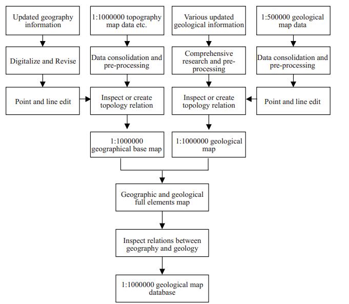
Figure 2.
Main route chart of the 1:1000000 geological map database.