
| Institute of Karst Geology, Chinese Academy of Geological Sciences | Host |

| Citation: |
YANG Chen, DENG Fei, SHI Xuguo. Monitoring subsidence characteristics of Baishazhou karst area in Wuhan with Sentinel-1 images from 2015 to 2019[J]. Carsologica Sinica, 2023, 42(3): 558-564. doi: 10.11932/karst2023y018

|
Monitoring subsidence characteristics of Baishazhou karst area in Wuhan with Sentinel-1 images from 2015 to 2019
-
Abstract
The karst region of southwest China includes , Guizhou, Yunnan, Guangxi, Sichuan, Hunan, Hubei, Guangdong and Chongqing. The region has a warm and humid climate with heavy rain, making it a zone of high incidence of geological disasters. China experienced 6,181 geological disasters in 2019, up 108.4% from 2,966 in 2018. These disasters caused the direct economic loss of 1.7 billion yuan, accounting for 61.4% of the total in China. Two hundred and twenty-four people are dead and missing, with 98 people in the karst mountainous areas of Chongqing, Sichuan, Guizhou, and Yunnan.
Numerous Chinese cities, including Guiyang, Guilin, Wuhan, Shenzhen, Guangzhou, etc., are situated in karst regions. According to statistics, more than 30 large and medium-sized cities and 420 counties and cities in China are located in high-risk locations for ground collapse. One of the primary causes of geological disasters like ground collapse and ground deformation in cities is the development of subsurface karst, abundant karst groundwater, and a specific thickness of soil layer. In Wuhan, there is a sizable region of covered karst with extremely complicated geological conditions that are primarily distributed in an NWW-SEE direction. The Yangtze River is crossed by several karst belts. Consequently, karst environmental geological problems are widespread in this region, and karst geological disasters have resulted in considerable financial losses. The survey data shows that there have been more than 40 karst collapses since 1994. Human engineering activities have increased in intensity with the ongoing urbanization. Geological disasters have been happening more frequently year after year.
The technologies such geological radar detection, the automatic monitoring of sensor for water pressure dynamic change in karst pipeline system, the survey monitoring with the precise level, GPS monitoring, Interferometric Synthetic Aperture Radar (InSAR), etc. are used to monitor surface deformation in karst areas. Among them, InSAR has been widely used as a method to monitor wide-range deformation with high precision in recent years. InSAR shows its advantages of all-weather, all-time, extensive spatial coverage, weather durability, and high precision, compared to other conventional monitoring techniques. In this study, the researchers used InSAR technology to conduct time series analysis on the data of Synthetic Aperture Radar (SAR) such as TerraSAR-X, COSMOSkyMed, Sentinel-1, Radarsat-2, etc. This data was obtained in Wuhan at different time periods, which can indicate that the subsidence mainly occurred in soft soil areas and karst areas with intensified human activities.
Situated in Wuhan at 30° 28′ 0′′–30° 32′ 24′′ north latitude and 114° 12′ 30′′–114° 18′ 45′′ east longitude, the study area covers the embankment of the Yangtze River and the Zhoutou sub-district in Hanyang district, Baishazhou sub-district in Wuchang district, and Zhangjiawan sub-district and Qingling sub-district in Hongshan district, in which the alluvial lacustrine plain and the denudation accumulation hillock are dominant landforms and the terrace is developed in the river valley. Holocene loose sediments from the Quaternary primarily cover the surface. Clayey soil makes up the higher portion of the lithology, and silty fine sand makes up the lower portion. The risk of a karst collapse is high because the loose deposits are buried beneath soluble carbonate rocks. The historical karst collapse spots in the study area, mainly situated in the alluvial lacustrine plain. Due to intensified human activities, the incidence of karst collapse has also been increasing year by year, which can be indicated by 23 karst collapses between 1931 and 2019.
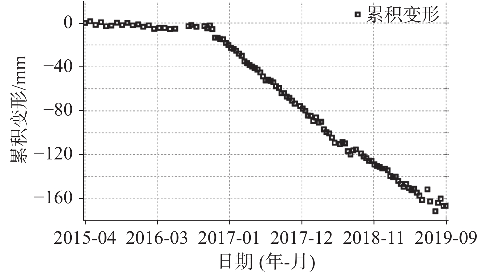
In this study, the elevated orbit Sentinel-1 SAR data set covering the high incidence area of karst collapse in Baishazhou, Wuhan, was analyzed with the time series of InSAR. Additionally, the land subsidence in the study area was identified and analyzed from April 2015 to September 2019. In the study area, the surface is mainly covered by loose deposits of the Quaternary Holocene, with cohesive soil in the upper part and fine sand in the lower part. The underlying soluble carbonate rocks under loose deposits may pose a high risk of karst collapse. Land subsidence resulted from the weight of the Quaternary soil covering the karst area has significantly increased by the concentrated summer rain. At high incidence zones of karst collapse in Baishazhou sub-district and Zhangjiawan sub-district, seasonal deformation signals connected to rainfall are discovered based on time series analysis, and the deformation rate is roughly 15 mm·a−1. Attributed to human construction activities, ground subsidence with a maximum deformation rate of 30 mm·a−1 was also discovered in the depot of Metro Line 6 and Qingling sub-district. This study establishes the value of InSAR technology in identifying geological risks in karst regions. A significant amount of SAR data can be offered for geological disasters in karst areas thanks to the development of Sentinel-1 and the upcoming NISAR mission of the United States. It is anticipated that, in the future, land subsidence monitoring products with large range, high precision and hightime-resolution will be available for the prevention and control of geological disasters.
-
Keywords:
- karst area /
- surface subsidence /
- time series InSAR /
- rainfall
-

-
References
[1] 夏日元, 蒋忠诚, 邹胜章, 曹建华, 覃小群, 苏春田, 罗为群, 周立新. 岩溶地区水文地质环境地质综合调查工程进展[J]. 中国地质调查, 2017, 4(1):1-10. XIA Riyuan, JIANG Zhongcheng, ZOU Shengzhang, CAO Jianhua, QIN Xiaoqun, SU Chuntian, LUO Weiqun, ZHOU Lixin. Progress of hydrogeology and environmental geology comprehensive survey in karst area[J]. Geological Survey of China, 2017, 4(1):1-10. [2] 吴应科, 毕于远, 郭纯青. 西南岩溶区岩溶基本特征与资源、环境、社会、经济综述[J]. 中国岩溶, 1998, 17(2):141-150. WU Yingke, BI Yuyuan, GUO Chunqing. A summary of basic features, resources, environment, sociality and economy in the karst areas of South-West China[J]. Casologica Sinica, 1998, 17(2):141-150. [3] 自然资源部地质灾害技术指导中心. 全国地质灾害通报(2019年)[Z]. 北京, 2019. Geological Disaster Technical Guidance Center of the Ministry of Natural Resources. National Geological Hazard Bulletin (2019)[Z]. Beijing, 2019. [4] 贺凯, 李滨, 赵超英, 高杨, 陈立权, 刘朋飞. 基于易滑地质结构与多源数据差异的岩溶山区大型崩滑灾害识别研究[J]. 中国岩溶, 2020, 39(4):467-477. HE Kai, LI Bin, ZHAO Chaoying, GAO Yang, CHEN Liquan, LIU Pengfei. Identification of large-scale landslides in karst mountainous areas based on the difference between the slippery geological structure and multi-source data[J]. Carsologica Sinica, 2020, 39(4):467-477. [5] 罗小杰, 沈建. 我国岩溶地面塌陷研究进展与展望[J]. 中国岩溶, 2018, 37(1):101-111. LUO Xiaojie, SHEN Jian. Research progress and prospect of karst ground collapse in China[J]. Carsologica Sinica, 2018, 37(1):101-111. [6] 邓忠, 李珊, 高武振, 康志强. 覆盖型岩溶区城市地下轨道交通建设引发地质灾害风险与对策[J]. 城市地质, 2020, 15(3):261-266. DENG Zhong, LI Shan, GAO Wuzhen, KANG Zhiqiang. Geological disaster risk caused by construction of urban underground rail transit in covered karst area and its preventive measures[J]. Urban Geology, 2020, 15(3):261-266. [7] 沈铭, 杨涛, 赵新建. 武汉市岩溶地面塌陷监测技术探讨[J]. 资源环境与工程, 2014(2):177-180. doi: 10.3969/j.issn.1671-1211.2014.02.013 SHEN Ming, YANG Tao, ZHAO Xinjian. Discussion on monitoring technology of karst surface collapse[J]. Resources Environment & Engineering, 2014(2):177-180. doi: 10.3969/j.issn.1671-1211.2014.02.013 [8] 涂婧, 杨涛, 刘长宪, 吕玲, 彭惠. 基于GIS武汉岩溶塌陷区岩溶发育规律研究[J]. 资源环境与工程, 2014, 28(1):49-52, 73. doi: 10.3969/j.issn.1671-1211.2014.01.013 TU Jing, YANG Tao, LIU Changxian, LYU Ling, PENG Hui. Study on karst development law in Wuhan karst collapse area based on GIS[J]. Resource Environment and Engineering, 2014, 28(1):49-52, 73. doi: 10.3969/j.issn.1671-1211.2014.01.013 [9] 罗小杰. 武汉地区碳酸盐岩“六带五型”划分与岩溶地质灾害防治[J]. 水利学报, 2014, 45(2):171-179. LUO Xiaojie. Division of "Six Belts and Five Types" of carbonate region and control of karst geological disaster in Wuhan[J]. Journal of Hydraulic Engineering, 2014, 45(2):171-179. [10] 廖明生, 张路, 史绪国, 蒋亚楠, 董杰, 刘宇舟. 滑坡变形雷达遥感监测方法与实践[M]. 北京: 科学出版社, 2017. LIAO Mingsheng, ZHANG Lu, SHI Xuguo, JIANG Yanan, DONG Jie, LIU Yuzhou. Methods and practice of landslide deformation radar remote sensing monitoring[M]. Beijing: Science Press, 2017. [11] 白林, 江利明, 汪汉胜. 利用高分辨率TerraSAR-X数据监测武汉地区2013~2015年地面沉降[J]. 大地测量与地球动力学, 2019, 39(8):832-836. BAI Lin, JIANG Liming, WANG Hansheng. Monitoring ground subsidence in Wuhan City with high-resolution TerraSAR-X images from 2013 to 2015[J]. Journal of Geodesy and Geodynamics, 2019, 39(8):832-836. [12] Bai L, Jiang L M, Wang H S, Sun Q S. Spatiotemporal characterization of land subsidence and uplift (2009–2010) over Wuhan in Central China revealed by TerraSAR-X InSAR analysis[J]. Remote Sensing, 2016, 8(4): 350. [13] Jiang Haonan . Land subsidence in Wuhan revealed using a non-linear PSInSAR approach with long time series of COSMO-SkyMed SAR data[J]. Remote Sensing, 2021, 13(7): 1256. [14] 孙伟, 李江卫, 白洁, 童欣. 利用PS-InSAR技术监测武汉市主城区地面沉降[J]. 城市勘测, 2019(5):120-125. doi: 10.3969/j.issn.1672-8262.2019.05.029 SUN Wei, LI Jiangwei, BAI Jie, TONG Xin. Using the PS-InSAR technique to monitor Wuhan urban district land subsidence[J]. Urban Geotechnical Investigation & Surveying, 2019(5):120-125. doi: 10.3969/j.issn.1672-8262.2019.05.029 [15] Zhou L, Guo J M, Hu J Y, Li J W, Xu Y F, Pan Y J, Shi M. Wuhan surface subsidence analysis in 2015–2016 based on Sentinel-1A data by SBAS-InSAR[J]. Remote Sensing, 2017, 9(10): 982. [16] Zhang Y, Liu Y, Jin M, Jing Y, Liu Y, Liu Y, Sun W, Wei J, Chen Y. Monitoring land subsidence in Wuhan City (China) using the SBAS-InSAR method with radarsat-2 imagery data[J]. Sensors, 2019, 19 (3): 743. [17] Ferretti A, Prati C, Rocca F. Permanent scatterers in SAR interferometry[J]. IEEE Transactions on Geoscience and Remote Sensing, 2001, 39(1): 8-20. [18] Shi X G, Yang C, Zhang L, Jiang H J, Liao M S, Zhang L, Liu XG. Mapping and characterizing displacements of active loess slopes along the upstream Yellow River with multi-temporal InSAR datasets[J]. Science of the Total Environment, 2019, 674: 200-210. [19] Berardino P, Fornaro G, Lanari R. A new algorithm for surface deformation monitoring based on small baseline differential SAR interferograms[J]. IEEE Transactions on Geoscience and Remote Sensing, 2002, 40 (11): 2375-2383. [20] 李长安, 张玉芬, 庞设典, 官善友. 以地貌单元为依据的工程地质分区研究: 以武汉市都市发展区城市地质研究为例[J]. 地质论评, 2019, 65(3):645-652. LI Chang'an, ZHANG Yufen, PANG Shedian, GUAN Shanyou. Study on engineering geological zoning based on geomorphologic units: A case study of the Wuhan metropolitan development area[J]. Geological Review, 2019, 65(3):645-652. [21] 官善友, 朱锐, 庞设典, 江丹. 武汉都市发展区工程地质分区研究[J]. 城市勘测, 2016(6):172-176. doi: 10.3969/j.issn.1672-8262.2016.06.046 GUAN Shanyou, ZHU Rui, PANG Shedian, JIANG Dan. The study for engineering geological zonation of metropolitan development area in Wuhan[J]. Urban Geotechnical Investigation & Surveying, 2016(6):172-176. doi: 10.3969/j.issn.1672-8262.2016.06.046 [22] 徐贵来. 武汉市覆盖层−岩溶地面塌陷形成机理与危险性评价[D]. 武汉: 中国地质大学, 2016. XU Guilai. Formation mechanism and risk assessment of overburden-karst ground collapse in Wuhan[D]. Wuhan: China University of Geosciences, 2016. [23] 涂婧, 魏瑞均, 杨戈欣, 刘长宪, 金小刚, 李海涛. 湖北武汉岩溶塌陷时空分布规律及其影响因素分析[J]. 中国地质灾害与防治学报, 2019, 30(6):68-73,93. TU Jing, WEI Ruijun, YANG Gexin, LIU Changxian, JIN Xiaogang, LI Haitao. Analysis on spatial and temporal distribution characteristics of karst collapse and its influence factors in Wuhan City of Hubei Province[J]. Chinese Journal of Geological Hazards and Prevention, 2019, 30(6):68-73,93. [24] 郑晓明, 金小刚, 陈标典, 刘鹏瑞, 杨戈欣, 李海涛, 杨涛. 湖北武汉岩溶塌陷成因机理与致塌模式[J]. 中国地质灾害与防治学报, 2019, 30(5):75-82. ZHENG Xiaoming, JIN Xiaogang, CHEN Biaodian, LIU Pengrui, YANG Gexin, LI Haitao, YANG Tao. Mechanism and modes of karst collapse in Wuhan City, Hubei Province[J]. The Chinese Journal of Geological Hazard and Control, 2019, 30(5):75-82. [25] 陈冬琴. 武汉市青菱乡岩溶塌陷机理及数值模拟研究[D]. 武汉: 中国地质大学, 2016. CHEN Dongqin. Research on karst collapse mechanism and numerical simulation in Qingling township, Wuhan City[D]. Wuhan: China University of Geosciences, 2016. [26] Li Ying, He Zhongze, Yan Guihua, Han Fengyou. Foundation pit dewatering and ground subsidence in binary structural stratum of Wuhan[J]. Advanced Materials Research, 2013, 639-640: 694-699. -
Access History

Figures(7)

Export File
Citation
YANG Chen, DENG Fei, SHI Xuguo. Monitoring subsidence characteristics of Baishazhou karst area in Wuhan with Sentinel-1 images from 2015 to 2019[J]. Carsologica Sinica, 2023, 42(3): 558-564. doi: 10.11932/karst2023y018
Format
Content
 DownLoad:


-
Figure 1.
Geomorphological zoning of the experimental area
-
Figure 2.
Sentinel-1 interference pair combination
-
Figure 3.
Average deformation rate of experimental area extracted by Sentinel-1 data
-
Figure 4.
Land subsidence rate in the karst area of Baishazhou
-
Figure 5.
Cumulative settlement and rainfall at P1
-
Figure 6.
Ground subsidence rate of Metro Line 6
-
Figure 7.
Cumulative settlement and rainfall at P2